Cieutat
Gemeente in Frankrijk  | |||
|---|---|---|---|
 | |||
  | |||
| Situering | |||
| Regio | Occitanie | ||
| Departement | Hautes-Pyrénées (65) | ||
| Arrondissement | Bagnères-de-Bigorre | ||
| Kanton | La Vallée de l'Arros et des Baïses | ||
| Coördinaten | 43° 8′ NB, 0° 13′ OL | ||
| Algemeen | |||
| Oppervlakte | 18,78 km² | ||
| Inwoners (1 januari 2021) | 609 (32 inw./km²) | ||
| Hoogte | 327 - 589 m | ||
| Overig | |||
| Postcode | 65200 | ||
| INSEE-code | 65147 | ||
| |||

Cieutat is een gemeente in het Franse departement Hautes-Pyrénées (regio Occitanie) en telt 518 inwoners (1999). De plaats maakt deel uit van het arrondissement Bagnères-de-Bigorre.
-
 Gemeentehuis
 -
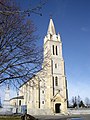 Kerk Saint-Barthélémy


Geografie
De oppervlakte van Cieutat bedraagt 18,6 km², de bevolkingsdichtheid is 27,8 inwoners per km².

Demografie
Onderstaande figuur toont het verloop van het inwonertal (bron: INSEE-tellingen).

Externe links
Mediabestanden
Commons heeft mediabestanden in de categorie Cieutat.
- (fr) Statistische informatie op de website van INSEE


