Daventry (district)
Niet-metropolitaans district in Engeland  | |||
|---|---|---|---|
  | |||
| Situering | |||
| Land | Engeland | ||
| County | Northamptonshire | ||
| Regio | East Midlands | ||
| Coördinaten | 52°18'NB, 1°3'WL | ||
| Algemeen | |||
| Oppervlakte | 662,6157[1] km² | ||
| Inwoners (2018[2]) | 84.484 (128 inw./km²) | ||
| ONS-code | E07000151 | ||
| Website | Officiële website | ||
| Detailkaart | |||
 | |||
| |||

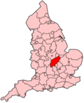
Daventry is een Engels district in het shire-graafschap (non-metropolitan county OF county) Northamptonshire en telt 84.000 inwoners. Hoofdplaats is Daventry.
Civil parishes in district Daventry
Althorp, Arthingworth, Ashby St Ledgers, Badby, Barby, Boughton, Braunston, Brington, Brixworth, Brockhall, Byfield, Canons Ashby, Catesby, Charwelton, Church with Chapel Brampton, Clay Coton, Clipston, Cold Ashby, Cottesbrooke, Creaton, Crick, Daventry, Dodford, Draughton, East Farndon, East Haddon, Elkington, Everdon, Farthingstone, Fawsley, Flore, Great Oxendon, Guilsborough, Hannington, Harlestone, Haselbech, Hellidon, Holcot, Holdenby, Hollowell, Kelmarsh, Kilsby, Lamport, Lilbourne, Long Buckby, Maidwell, Marston Trussell, Moulton, Naseby, Newnham, Norton, Old, Overstone, Pitsford, Preston Capes, Ravensthorpe, Scaldwell, Sibbertoft, Spratton, Stanford, Staverton, Stowe IX Churches, Sulby, Thornby, Walgrave, Watford, Weedon Bec, Welford, Welton, West Haddon, Whilton, Winwick, Woodford Halse, Yelvertoft.
Bronnen, noten en/of referenties
- ↑ Office for National Statistics → Download → SAM_for_Administrative_Areas_(2018).zip → SAM_LAD_DEC_2018_UK.xlsx. Gearchiveerd op 12 juni 2023.
- ↑ https://www.ons.gov.uk/file?uri=/peoplepopulationandcommunity/populationandmigration/populationestimates/datasets/populationestimatesforukenglandandwalesscotlandandnorthernireland/mid20182019laboundaries/ukmidyearestimates20182019ladcodes.xls Schatting Office for National Statistics: knop MYE5 → kolom Estimated Population mid-2018]
- Volkstelling 2001, Office for National Statistics


