Milford Mill
Plaats in de Verenigde Staten  | |||
|---|---|---|---|
  | |||
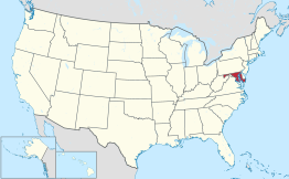 Locatie van Maryland in de VS | |||
| Situering | |||
| County | Baltimore County | ||
| Type plaats | Census-designated place | ||
| Staat | Maryland | ||
| Coördinaten | 39° 21′ NB, 76° 46′ WL | ||
| Algemeen | |||
| Oppervlakte | 18,1 km² | ||
| - land | 18,1 km² | ||
| - water | 0,0 km² | ||
| Inwoners (2000) | 26.527 | ||
| Hoogte | 151 m | ||
| Overig | |||
| FIPS-code | 52562 | ||
| |||

Milford Mill is een plaats (census-designated place) in de Amerikaanse staat Maryland, en valt bestuurlijk gezien onder Baltimore County.
Demografie
Bij de volkstelling in 2000 werd het aantal inwoners vastgesteld op 26.527.[1]
Geografie
Volgens het United States Census Bureau beslaat de plaats een oppervlakte van 18,1 km², geheel bestaande uit land.
Plaatsen in de nabije omgeving
De onderstaande figuur toont nabijgelegen plaatsen in een straal van 8 km rond Milford Mill.
 Milford Mill
 Garrison (6 km)
 Lochearn (3 km)Owings Mills (8 km)Pikesville (6 km)Randallstown (4 km)Woodlawn (5 km)
Externe link
- (en) Statistieken, kaarten en andere informatie over Milford-Mill op city-data.com
Bronnen, noten en/of referenties
- ↑ (en) U.S. Census Bureau. Census 2000 Summary File 1


