Walworth County (South Dakota)
County in de Verenigde Staten  | |||
|---|---|---|---|
 | |||
| Situering | |||
| Staat | South Dakota | ||
| Coördinaten | 45°25'48"NB, 100°1'48"WL | ||
| Algemeen | |||
| Oppervlakte | 1.927 km² | ||
| - land | 1.833 km² | ||
| - water | 94 km² | ||
| Inwoners (2010) | 5.438 (3 inw./km²) | ||
| Overig | |||
| FIPS-code | 46129 | ||
| Website | Officiële website | ||
| Foto's | |||
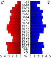 Bevolkingspiramide Walworth County | |||
| Statistieken volkstelling Walworth County | |||
| |||

Walworth County is een van de 66 county's in de Amerikaanse staat South Dakota.
De county heeft een landoppervlakte van 1.833 km² en telt 5.438 inwoners (volkstelling 2010).
Aurora County · Beadle County · Bennett County · Bon Homme County · Brookings County · Brown County · Brule County · Buffalo County · Butte County · Campbell County · Charles Mix County · Clark County · Clay County · Codington County · Corson County · Custer County · Davison County · Day County · Deuel County · Dewey County · Douglas County · Edmunds County · Fall River County · Faulk County · Grant County · Gregory County · Haakon County · Hamlin County · Hand County · Hanson County · Harding County · Hughes County · Hutchinson County · Hyde County · Jackson County · Jerauld County · Jones County · Kingsbury County · Lake County · Lawrence County · Lincoln County · Lyman County · Marshall County · McCook County · McPherson County · Meade County · Mellette County · Miner County · Minnehaha County · Moody County · Oglala Lakota County · Pennington County · Perkins County · Potter County · Roberts County · Sanborn County · Spink County · Stanley County · Sully County · Todd County · Tripp County · Turner County · Union County · Walworth County · Yankton County · Ziebach County


