Hemrik
Village in Friesland, Netherlands
Hemrik De Himrik | |
|---|---|
Village | |
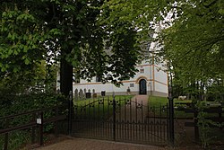 White church | |
 Flag  Coat of arms | |
 Location in Opsterland municipality | |
53°01′51″N 6°8′17″E / 53.03083°N 6.13806°E / 53.03083; 6.13806 | |
| Country |  Netherlands Netherlands |
| Province |  Friesland Friesland |
| Municipality |  Opsterland Opsterland |
| Area [1] | |
| • Total | 10.89 km2 (4.20 sq mi) |
| Elevation [2] | 5 m (16 ft) |
| Population (2021)[1] | |
| • Total | 755 |
| • Density | 69/km2 (180/sq mi) |
| Postal code | 8409[1] |
| Dialing code | 0516 |
Hemrik (West Frisian: De Himrik) is a village in the municipality of Opsterland in the east of Friesland, the Netherlands. It had a population of around 770 in January 2017.[3]
The village was first mentioned in 1315 as Hemericke, and means village area.[4] Hemrik developed on a sandy ridge in a heath and moorland region. Around 1750, the Opsterlandse Compagnonsvaart was dug for the excavation of peat.[5] A chapel existed in the village as early as 1315.[6] The Dutch Reformed church dates from 1739,[5] and is colloquially called White Church due its white plaster.[6]
Hemrik was home to 352 people in 1840.[6]
Gallery
-
 Farm near Hemrik
 -
 Burial vault
 -
 Children's play forest near Hemrik


References
- ^ a b c "Kerncijfers wijken en buurten 2021". Central Bureau of Statistics. Retrieved 2 April 2022.
- ^ "Postcodetool for 8409CJ". Actueel Hoogtebestand Nederland (in Dutch). Het Waterschapshuis. Retrieved 2 April 2022.
- ^ Kerncijfers wijken en buurten 2017 - CBS Statline
- ^ "Hemrik - (geografische naam)". Etymologiebank (in Dutch). Retrieved 2 April 2022.
- ^ a b Ronald Stenvert & Sabine Broekhoven (2000). "Hemrik" (in Dutch). Zwolle: Waanders. ISBN 90 400 9476 4. Retrieved 2 April 2022.
- ^ a b c "Hemrik". Plaatsengids (in Dutch). Retrieved 2 April 2022.
External links
![]() Media related to Hemrik at Wikimedia Commons
Media related to Hemrik at Wikimedia Commons
- v
- t
- e
Populated places in the municipality of Opsterland
- Gorredijk
- Bakkeveen
- Beetsterzwaag
- Frieschepalen
- Hemrik
- Jonkerslân
- Langezwaag
- Lippenhuizen
- Luxwoude
- Nij Beets
- Olterterp
- Siegerswoude
- Terwispel
- Tijnje
- Ureterp
- Wijnjewoude
- Industrial zone
- Drachten-Azeven [nl]
 | This Friesland location article is a stub. You can help Wikipedia by expanding it. |
- v
- t
- e


