List of listed buildings in Clunie, Perth and Kinross
This is a list of listed buildings in the parish of Clunie in Perth and Kinross, Scotland.
Map all coordinates using OpenStreetMap
Download coordinates as:
- KML
- GPX (all coordinates)
- GPX (primary coordinates)
- GPX (secondary coordinates)
List
| Name | Location | Date Listed | Grid Ref. [note 1] | Geo-coordinates | Notes | LB Number [note 2] | Image |
|---|---|---|---|---|---|---|---|
| Clunie Churchyard | 56°34′47″N 3°27′04″W / 56.579622°N 3.45115°W / 56.579622; -3.45115 (Clunie Churchyard) | Category C(S) | 5836 |  Upload Photo | |||
| Clunie Manse, Formerly | 56°34′45″N 3°27′05″W / 56.579242°N 3.45133°W / 56.579242; -3.45133 (Clunie Manse, Formerly) | Category C(S) | 5837 | Upload Photo | |||
| Laighwood House | 56°35′43″N 3°30′26″W / 56.595252°N 3.507352°W / 56.595252; -3.507352 (Laighwood House) | Category C(S) | 5849 | Upload Photo | |||
| Clunie Parish Church | 56°34′47″N 3°27′04″W / 56.579837°N 3.451207°W / 56.579837; -3.451207 (Clunie Parish Church) | Category B | 5883 | 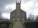 Upload another image | |||
| 'The Long Row' Craigie | 56°34′31″N 3°26′15″W / 56.575189°N 3.437518°W / 56.575189; -3.437518 ('The Long Row' Craigie) | Category B | 5845 | Upload Photo | |||
| Clunie Old Kirk, Fragment | 56°34′47″N 3°27′05″W / 56.579737°N 3.451317°W / 56.579737; -3.451317 (Clunie Old Kirk, Fragment) | Category B | 5835 | Upload Photo | |||
| Clunie Boathouse (Old) For Clunie Castle | 56°34′45″N 3°26′53″W / 56.579163°N 3.448104°W / 56.579163; -3.448104 (Clunie Boathouse (Old) For Clunie Castle) | Category C(S) | 5842 | Upload Photo | |||
| Roughstones Farm | 56°35′53″N 3°28′25″W / 56.598138°N 3.47349°W / 56.598138; -3.47349 (Roughstones Farm) | Category B | 5851 | Upload Photo | |||
| Clunie Castle | 56°34′47″N 3°26′43″W / 56.579655°N 3.445192°W / 56.579655; -3.445192 (Clunie Castle) | Category A | 5843 | 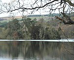 Upload another image | |||
| Craigton Cottage Butterston | 56°35′43″N 3°31′27″W / 56.595145°N 3.524204°W / 56.595145; -3.524204 (Craigton Cottage Butterston) | Category B | 5848 | Upload Photo | |||
| St. Catherine's Tower | 56°35′20″N 3°26′40″W / 56.588953°N 3.444554°W / 56.588953; -3.444554 (St. Catherine's Tower) | Category C(S) | 5852 | Upload Photo | |||
| Stars Of Forneth | 56°35′21″N 3°27′09″W / 56.589039°N 3.452634°W / 56.589039; -3.452634 (Stars Of Forneth) | Category B | 5853 | Upload Photo | |||
| Loch Cottage, On Clunie Castle Drive To Boathouse | 56°34′44″N 3°26′57″W / 56.578972°N 3.44909°W / 56.578972; -3.44909 (Loch Cottage, On Clunie Castle Drive To Boathouse) | Category C(S) | 5841 | Upload Photo | |||
| Forneth House | 56°35′07″N 3°27′04″W / 56.585362°N 3.451223°W / 56.585362; -3.451223 (Forneth House) | Category B | 5844 | Upload Photo | |||
| Milton Of Forneth, Bridge Over Lunan | 56°35′21″N 3°28′22″W / 56.589224°N 3.472785°W / 56.589224; -3.472785 (Milton Of Forneth, Bridge Over Lunan) | Category C(S) | 6193 | Upload Photo | |||
| Clunie Motte, Castle Hill | 56°34′47″N 3°26′57″W / 56.579744°N 3.449184°W / 56.579744; -3.449184 (Clunie Motte, Castle Hill) | Category B | 5839 | Upload Photo | |||
| The Ward, Clunie Summerhouse | 56°34′51″N 3°27′10″W / 56.580824°N 3.45284°W / 56.580824; -3.45284 (The Ward, Clunie Summerhouse) | Category C(S) | 5840 | Upload Photo | |||
| Benachally Monument Benachally Summit | 56°37′24″N 3°31′25″W / 56.623393°N 3.523615°W / 56.623393; -3.523615 (Benachally Monument Benachally Summit) | Category C(S) | 5847 | Upload Photo | |||
| Laighwood Steading | 56°35′44″N 3°30′33″W / 56.595438°N 3.509037°W / 56.595438; -3.509037 (Laighwood Steading) | Category C(S) | 5850 | Upload Photo | |||
| Clunie Castle, Gatepiers | 56°34′44″N 3°27′02″W / 56.578849°N 3.45042°W / 56.578849; -3.45042 (Clunie Castle, Gatepiers) | Category B | 5838 | Upload Photo | |||
| Bridge Over Lunan, East End Of Clunie Loch | 56°35′01″N 3°26′07″W / 56.58348°N 3.435374°W / 56.58348; -3.435374 (Bridge Over Lunan, East End Of Clunie Loch) | Category C(S) | 5846 | Upload Photo |
Key
The scheme for classifying buildings in Scotland is:
- Category A: "buildings of national or international importance, either architectural or historic; or fine, little-altered examples of some particular period, style or building type."[1]
- Category B: "buildings of regional or more than local importance; or major examples of some particular period, style or building type, which may have been altered."[1]
- Category C: "buildings of local importance; lesser examples of any period, style, or building type, as originally constructed or moderately altered; and simple traditional buildings which group well with other listed buildings."[1]
In March 2016 there were 47,288 listed buildings in Scotland. Of these, 8% were Category A, and 50% were Category B, with the remaining 42% being Category C.[2]
Notes
- ^ Sometimes known as OSGB36, the grid reference (where provided) is based on the British national grid reference system used by the Ordnance Survey.
• "Guide to National Grid". Ordnance Survey. Retrieved 12 December 2007.
• "Get-a-map". Ordnance Survey. Retrieved 17 December 2007. - ^ Historic Environment Scotland assign a unique alphanumeric identifier to each designated site in Scotland, for listed buildings this always begins with "LB", for example "LB12345".
References
- All entries, addresses and coordinates are based on data from Historic Scotland. This data falls under the Open Government Licence
- ^ a b c "What is Listing?". Historic Environment Scotland. Retrieved 29 May 2018.
- ^ Scotland's Historic Environment Audit 2016 (PDF). Historic Environment Scotland and the Built Environment Forum Scotland. pp. 15–16. Retrieved 29 May 2018.
- v
- t
- e
- Aberdalgie
- Aberfeldy
- Abernethy
- Abernyte
- Alyth
- Ardoch
- Arngask
- Auchterarder
- Auchtergaven
- Bendochy
- Blackford
- Blair Atholl
- Blairgowrie and Rattray
- Blairgowrie
- Caputh
- Cargill
- Cleish
- Clunie
- Collace
- Comrie
- Coupar Angus
- Crieff
- Dron
- Dull
- Dunbarney
- Dunkeld and Dowally
- Dunning
- Errol
- Findo Gask
- Forgandenny
- Forteviot
- Fortingall
- Fossoway
- Fowlis Wester
- Glendevon
- Inchture
- Kenmore
- Kettins
- Kilspindie
- Kinclaven
- Kinfauns
- Kinloch
- Kinnaird
- Kinnoull
- Kinross
- Kirkmichael
- Lethendy
- Liff and Benvie
- Little Dunkeld
- Logiealmond
- Logierait
- Longforgan
- Madderty
- Meigle
- Methven
- Moneydie
- Monzievaird and Strowan
- Moulin
- Muckhart
- Muthill
- Orwell
- Perth
- Pitlochry
- Portmoak
- Rattray
- Redgorton
- Rhynd
- Scone
- St Madoes
- St Martins
- Tibbermore
- Trinity Gask
- Weem


