List of listed buildings in Dull, Perth and Kinross
This is a list of listed buildings in the parish of Dull in Perth and Kinross, Scotland.
Map all coordinates using OpenStreetMap
Download coordinates as:
- KML
- GPX (all coordinates)
- GPX (primary coordinates)
- GPX (secondary coordinates)
List
| Name | Location | Date Listed | Grid Ref. [note 1] | Geo-coordinates | Notes | LB Number [note 2] | Image |
|---|---|---|---|---|---|---|---|
| Camserney Longhouse And Peat Shed | 56°37′12″N 3°55′47″W / 56.620075°N 3.929682°W / 56.620075; -3.929682 (Camserney Longhouse And Peat Shed) | Category A | 5732 |  Upload Photo | |||
| Turrerich Bridge Over River Quaich | 56°31′32″N 3°51′52″W / 56.525434°N 3.8645°W / 56.525434; -3.8645 (Turrerich Bridge Over River Quaich) | Category C(S) | 5739 | Upload Photo | |||
| St Adamnan's Parish Church Graveyard | 56°37′08″N 3°56′48″W / 56.618993°N 3.946643°W / 56.618993; -3.946643 (St Adamnan's Parish Church Graveyard) | Category B | 5748 | Upload Photo | |||
| Glengoulandie | 56°38′55″N 4°00′41″W / 56.648495°N 4.011484°W / 56.648495; -4.011484 (Glengoulandie) | Category C(S) | 5740 | Upload Photo | |||
| Tummel Bridge | 56°42′28″N 4°01′23″W / 56.707866°N 4.023099°W / 56.707866; -4.023099 (Tummel Bridge) | Category A | 5742 |  Upload another image | |||
| Foss And Tummel Parish Church, Foss | 56°41′55″N 3°58′40″W / 56.698638°N 3.977736°W / 56.698638; -3.977736 (Foss And Tummel Parish Church, Foss) | Category C(S) | 5743 | Upload Photo | |||
| St Adamnan's Parish Church Dull | 56°37′09″N 3°56′49″W / 56.619088°N 3.946892°W / 56.619088; -3.946892 (St Adamnan's Parish Church Dull) | Category B | 5747 |  Upload another image | |||
| Newhall Bridge Over River Tay | 56°35′55″N 3°58′25″W / 56.598539°N 3.973576°W / 56.598539; -3.973576 (Newhall Bridge Over River Tay) | Category B | 5757 | Upload Photo | |||
| Comrie Castle | 56°36′49″N 3°58′43″W / 56.61353°N 3.978514°W / 56.61353; -3.978514 (Comrie Castle) | Category B | 5759 | Upload Photo | |||
| Camserney, Redgorton | 56°37′19″N 3°55′43″W / 56.621951°N 3.928637°W / 56.621951; -3.928637 (Camserney, Redgorton) | Category C(S) | 51169 | Upload Photo | |||
| Dunskiag Farmhouse And Steading | 56°36′40″N 3°53′29″W / 56.61102°N 3.891465°W / 56.61102; -3.891465 (Dunskiag Farmhouse And Steading) | Category B | 6635 | Upload Photo | |||
| Garrow Bridge Over River Quaich | 56°32′22″N 3°54′41″W / 56.539366°N 3.911522°W / 56.539366; -3.911522 (Garrow Bridge Over River Quaich) | Category C(S) | 6194 | Upload Photo | |||
| Bolfracks | 56°36′37″N 3°55′15″W / 56.610298°N 3.920971°W / 56.610298; -3.920971 (Bolfracks) | Category B | 5737 | Upload Photo | |||
| Tullicro, East Cottage | 56°37′10″N 3°56′01″W / 56.619493°N 3.933581°W / 56.619493; -3.933581 (Tullicro, East Cottage) | Category C(S) | 5751 | Upload Photo | |||
| Manse Of Dull | 56°37′02″N 3°57′10″W / 56.617341°N 3.952865°W / 56.617341; -3.952865 (Manse Of Dull) | Category B | 5750 | Upload Photo | |||
| Newhall | 56°35′50″N 3°58′18″W / 56.597356°N 3.97169°W / 56.597356; -3.97169 (Newhall) | Category B | 5753 | Upload Photo | |||
| Amulree And Strathbraan Parish Church With Graveyard, Gates And Gatepiers | 56°30′30″N 3°47′26″W / 56.50836°N 3.790664°W / 56.50836; -3.790664 (Amulree And Strathbraan Parish Church With Graveyard, Gates And Gatepiers) | Category B | 6362 | 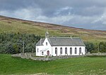 Upload another image | |||
| Foss And Tummel Parish Church, Graveyard | 56°41′55″N 3°58′40″W / 56.698529°N 3.977796°W / 56.698529; -3.977796 (Foss And Tummel Parish Church, Graveyard) | Category C(S) | 5744 | Upload Photo | |||
| Cross, Dull | 56°37′08″N 3°56′44″W / 56.618838°N 3.945624°W / 56.618838; -3.945624 (Cross, Dull) | Category B | 5749 | Upload Photo | |||
| Main Lodge And Gates, Taymouth Castle | 56°35′50″N 3°58′01″W / 56.597114°N 3.967068°W / 56.597114; -3.967068 (Main Lodge And Gates, Taymouth Castle) | Category B | 5752 | Upload Photo | |||
| Camserney, Old Mill Of Camserney And Mill House | 56°37′14″N 3°55′30″W / 56.620499°N 3.924928°W / 56.620499; -3.924928 (Camserney, Old Mill Of Camserney And Mill House) | Category B | 5734 | Upload Photo | |||
| Camserney, Smithy Cottage, Former Smithy And Limekiln | 56°37′18″N 3°55′29″W / 56.62166°N 3.924808°W / 56.62166; -3.924808 (Camserney, Smithy Cottage, Former Smithy And Limekiln) | Category B | 5738 | Upload Photo | |||
| Tullicro, West Cottage Including The Barn And The Bothy | 56°37′10″N 3°56′04″W / 56.619326°N 3.934501°W / 56.619326; -3.934501 (Tullicro, West Cottage Including The Barn And The Bothy) | Category B | 5756 | Upload Photo | |||
| Comrie Cottage (Formerly: Until Recently Property Of Comrie Farm, Now In Process Of Sale) | 56°36′50″N 3°59′14″W / 56.613903°N 3.98722°W / 56.613903; -3.98722 (Comrie Cottage (Formerly: Until Recently Property Of Comrie Farm, Now In Process Of Sale)) | Category B | 5760 | Upload Photo | |||
| Comrie Farm Steading, Millhouse, Tower House, Ghillies House And The Courtyard | 56°36′50″N 3°59′34″W / 56.613788°N 3.992754°W / 56.613788; -3.992754 (Comrie Farm Steading, Millhouse, Tower House, Ghillies House And The Courtyard) | Category B | 5761 | Upload Photo | |||
| Grampian Hydro Electric Scheme, Tummel Power Station | 56°42′23″N 4°01′16″W / 56.706397°N 4.021141°W / 56.706397; -4.021141 (Grampian Hydro Electric Scheme, Tummel Power Station) | Category A | 51715 | Upload Photo | |||
| Keltneyburn Hall | 56°37′07″N 4°00′01″W / 56.618547°N 4.000209°W / 56.618547; -4.000209 (Keltneyburn Hall) | Category C(S) | 6361 | Upload Photo | |||
| Tomphubil Limekiln | 56°40′00″N 3°59′44″W / 56.666553°N 3.99554°W / 56.666553; -3.99554 (Tomphubil Limekiln) | Category B | 5741 | Upload Photo | |||
| Camserney, Crachan Cottage Including Ancillary Buildings | 56°37′21″N 3°55′49″W / 56.62241°N 3.930339°W / 56.62241; -3.930339 (Camserney, Crachan Cottage Including Ancillary Buildings) | Category B | 5758 | Upload Photo |
Key
The scheme for classifying buildings in Scotland is:
- Category A: "buildings of national or international importance, either architectural or historic; or fine, little-altered examples of some particular period, style or building type."[1]
- Category B: "buildings of regional or more than local importance; or major examples of some particular period, style or building type, which may have been altered."[1]
- Category C: "buildings of local importance; lesser examples of any period, style, or building type, as originally constructed or moderately altered; and simple traditional buildings which group well with other listed buildings."[1]
In March 2016 there were 47,288 listed buildings in Scotland. Of these, 8% were Category A, and 50% were Category B, with the remaining 42% being Category C.[2]
Notes
- ^ Sometimes known as OSGB36, the grid reference (where provided) is based on the British national grid reference system used by the Ordnance Survey.
• "Guide to National Grid". Ordnance Survey. Retrieved 12 December 2007.
• "Get-a-map". Ordnance Survey. Retrieved 17 December 2007. - ^ Historic Environment Scotland assign a unique alphanumeric identifier to each designated site in Scotland, for listed buildings this always begins with "LB", for example "LB12345".
References
- All entries, addresses and coordinates are based on data from Historic Scotland. This data falls under the Open Government Licence
- ^ a b c "What is Listing?". Historic Environment Scotland. Retrieved 29 May 2018.
- ^ Scotland's Historic Environment Audit 2016 (PDF). Historic Environment Scotland and the Built Environment Forum Scotland. pp. 15–16. Retrieved 29 May 2018.
- v
- t
- e
- Aberdalgie
- Aberfeldy
- Abernethy
- Abernyte
- Alyth
- Ardoch
- Arngask
- Auchterarder
- Auchtergaven
- Bendochy
- Blackford
- Blair Atholl
- Blairgowrie and Rattray
- Blairgowrie
- Caputh
- Cargill
- Cleish
- Clunie
- Collace
- Comrie
- Coupar Angus
- Crieff
- Dron
- Dull
- Dunbarney
- Dunkeld and Dowally
- Dunning
- Errol
- Findo Gask
- Forgandenny
- Forteviot
- Fortingall
- Fossoway
- Fowlis Wester
- Glendevon
- Inchture
- Kenmore
- Kettins
- Kilspindie
- Kinclaven
- Kinfauns
- Kinloch
- Kinnaird
- Kinnoull
- Kinross
- Kirkmichael
- Lethendy
- Liff and Benvie
- Little Dunkeld
- Logiealmond
- Logierait
- Longforgan
- Madderty
- Meigle
- Methven
- Moneydie
- Monzievaird and Strowan
- Moulin
- Muckhart
- Muthill
- Orwell
- Perth
- Pitlochry
- Portmoak
- Rattray
- Redgorton
- Rhynd
- Scone
- St Madoes
- St Martins
- Tibbermore
- Trinity Gask
- Weem


