National Register of Historic Places listings in Butler County, Ohio

This is a list of the National Register of Historic Places listings in Butler County, Ohio.
This is intended to be a complete list of the properties and districts on the National Register of Historic Places in Butler County, Ohio, United States. The locations of National Register properties and districts for which the latitude and longitude coordinates are included below, may be seen in an online map.[1]
There are 92 properties and districts listed on the National Register in the county, including 3 National Historic Landmarks. Another 3 properties were once listed but have been removed.
This National Park Service list is complete through NPS recent listings posted June 7, 2024.[2]
Map all coordinates using OpenStreetMap
Download coordinates as:
- KML
- GPX (all coordinates)
- GPX (primary coordinates)
- GPX (secondary coordinates)
Current listings
| [3] | Name on the Register[4] | Image | Date listed[5] | Location | City or town | Description |
|---|---|---|---|---|---|---|
| 1 | Dr. William S. Alexander House |  | March 18, 1987 (#86003498) | 22 N. College Ave. 39°30′40″N 84°44′44″W / 39.511111°N 84.745556°W / 39.511111; -84.745556 (Dr. William S. Alexander House) | Oxford | |
| 2 | Anderson-Shaffer House | 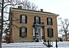 | January 18, 1974 (#74001402) | 404 Ross Ave. 39°24′15″N 84°34′18″W / 39.404167°N 84.571667°W / 39.404167; -84.571667 (Anderson-Shaffer House) | Hamilton | |
| 3 | Augspurger Grist Mill | Upload image | November 1, 1984 (#84000211) | Wayne-Madison Rd. at Woodsdale 39°25′48″N 84°28′38″W / 39.430000°N 84.477222°W / 39.430000; -84.477222 (Augspurger Grist Mill) | St. Clair Township | Grist mill built in 1868 in the company town of the Augsburger Paper Company; appears to have been demolished. |
| 4 | Augspurger Paper Company Rowhouse 1 |  | November 1, 1984 (#84000216) | 1698 Wayne-Madison Rd. at Woodsdale[6] 39°26′02″N 84°28′33″W / 39.433889°N 84.475833°W / 39.433889; -84.475833 (Augspurger Paper Company Rowhouse 1) | Madison Township | |
| 5 | Augspurger Paper Company Rowhouse 2 |  | November 1, 1984 (#84000215) | 1692 Wayne-Madison Rd. at Woodsdale[7] 39°26′01″N 84°28′33″W / 39.433611°N 84.475833°W / 39.433611; -84.475833 (Augspurger Paper Company Rowhouse 2) | Madison Township | |
| 6 | Augspurger Schoolhouse |  | November 1, 1984 (#84000212) | Wayne-Madison Rd. at Woodsdale 39°26′06″N 84°28′32″W / 39.435000°N 84.475694°W / 39.435000; -84.475694 (Augspurger Schoolhouse) | Madison Township | |
| 7 | Frederick Augspurger Farm | 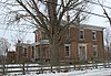 | August 3, 1984 (#84002900) | 1856 Wayne-Madison Rd., south of Trenton 39°26′18″N 84°28′33″W / 39.438333°N 84.475833°W / 39.438333; -84.475833 (Frederick Augspurger Farm) | Madison Township | |
| 8 | John Augspurger Farm No. 1 | 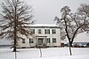 | August 3, 1984 (#84002901) | 2731 Woodsdale Rd., south of Trenton 39°27′51″N 84°27′02″W / 39.464167°N 84.450556°W / 39.464167; -84.450556 (John Augspurger Farm No. 1) | Madison Township | Demolished |
| 9 | John Augspurger Farm No. 2 | 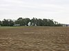 | November 1, 1984 (#84000208) | 3046 Pierson Rd. 39°27′57″N 84°27′34″W / 39.465833°N 84.459444°W / 39.465833; -84.459444 (John Augspurger Farm No. 2) | Trenton | |
| 10 | Samuel Augspurger Farm |  | November 1, 1984 (#84000209) | 2070 Woodsdale Rd., south of Trenton 39°26′40″N 84°27′42″W / 39.444444°N 84.461667°W / 39.444444; -84.461667 (Samuel Augspurger Farm) | Madison Township | |
| 11 | Samuel Augspurger House | 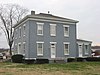 | November 1, 1984 (#84000213) | 1659 Wayne-Madison Rd. at Woodsdale[8] 39°25′58″N 84°28′36″W / 39.432778°N 84.476667°W / 39.432778; -84.476667 (Samuel Augspurger House) | St. Clair Township | |
| 12 | Austin-Magie Farm and Mill District |  | December 21, 1982 (#82001360) | Section 14 in Oxford Township 39°31′32″N 84°43′56″W / 39.525556°N 84.732222°W / 39.525556; -84.732222 (Austin-Magie Farm and Mill District) | Oxford Township | |
| 13 | Beckett-Manrod House |  | November 11, 1977 (#77001044) | 2019 Stillwell-Beckett Rd., northwest of Hamilton 39°27′10″N 84°37′42″W / 39.452778°N 84.628333°W / 39.452778; -84.628333 (Beckett-Manrod House) | Hanover Township | |
| 14 | Benninghofen House |  | May 17, 1973 (#73001388) | 327 N. 2nd St. 39°24′14″N 84°33′37″W / 39.403889°N 84.560278°W / 39.403889; -84.560278 (Benninghofen House) | Hamilton | |
| 15 | Big Four Depot |  | December 24, 2013 (#13000979) | 25 Charles St. 39°30′50″N 84°23′32″W / 39.513889°N 84.392222°W / 39.513889; -84.392222 (Big Four Depot) | Middletown | |
| 16 | Butler County Courthouse | 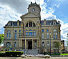 | June 22, 1981 (#81000429) | 2nd and High Sts. 39°23′59″N 84°33′46″W / 39.399722°N 84.562778°W / 39.399722; -84.562778 (Butler County Courthouse) | Hamilton | |
| 17 | Central Avenue Historic District |  | August 8, 2014 (#14000480) | Central Ave. 39°30′59″N 84°24′08″W / 39.516389°N 84.40222°W / 39.516389; -84.40222 (Central Avenue Historic District) | Middletown | |
| 18 | Champion Coated Paper Company |  | September 9, 2019 (#100004357) | 601 North B St. 39°24′37″N 84°33′37″W / 39.4102°N 84.5602°W / 39.4102; -84.5602 (Champion Coated Paper Company) | Hamilton | |
| 19 | Cochran Farm |  | July 16, 1973 (#73001390) | 2900 State Route 129, west of Millville 39°23′18″N 84°39′35″W / 39.388472°N 84.659722°W / 39.388472; -84.659722 (Cochran Farm) | Ross Township | |
| 20 | Dayton-Campbell Historic District | 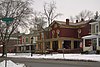 | June 30, 1983 (#83001947) | Primarily Dayton, High, and Campbell Ave. between 6th and 11th Sts. 39°23′55″N 84°33′07″W / 39.398611°N 84.551944°W / 39.398611; -84.551944 (Dayton-Campbell Historic District) | Hamilton | |
| 21 | Demoret Mound | Upload image | October 21, 1975 (#75001337) | 2,700 feet (820 m) west of the lake at the former Ross Trails Girl Scout Camp[9]: 51 | Ross Township | |
| 22 | Henry P. Deuscher House |  | February 9, 1984 (#84002902) | 2385 Woodsdale Rd., south of Trenton 39°27′06″N 84°26′47″W / 39.451667°N 84.446389°W / 39.451667; -84.446389 (Henry P. Deuscher House) | Madison Township | |
| 23 | Zachariah Price Dewitt Cabin | 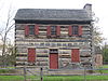 | April 13, 1973 (#73001392) | East of Oxford on State Route 73 39°30′38″N 84°43′07″W / 39.510556°N 84.718611°W / 39.510556; -84.718611 (Zachariah Price Dewitt Cabin) | Oxford Township | |
| 24 | Dixon-Globe Opera House-Robinson-Schwenn Building |  | July 14, 2000 (#00000799) | 221 High St. 39°23′58″N 84°33′39″W / 39.399444°N 84.560833°W / 39.399444; -84.560833 (Dixon-Globe Opera House-Robinson-Schwenn Building) | Hamilton | |
| 25 | Edgeton |  | April 3, 1975 (#75001331) | 575 Harrison Ave. 39°24′21″N 84°35′11″W / 39.405833°N 84.586389°W / 39.405833; -84.586389 (Edgeton) | Hamilton | |
| 26 | Christian Ehresman Farm | 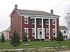 | August 3, 1984 (#84002903) | 900 Woodsdale Rd. 39°28′12″N 84°27′11″W / 39.470000°N 84.453056°W / 39.470000; -84.453056 (Christian Ehresman Farm) | Trenton | |
| 27 | Elliott and Stoddard Halls |  | April 3, 1973 (#73001391) | Miami University campus 39°30′31″N 84°44′07″W / 39.508611°N 84.735278°W / 39.508611; -84.735278 (Elliott and Stoddard Halls) | Oxford | |
| 28 | Fairfield Township Works I | 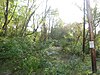 | November 5, 1971 (#71000631) | Eastern bank of the Great Miami River, 4 miles (6.4 km) above Hamilton[9]: 43 39°25′28″N 84°29′00″W / 39.424444°N 84.483333°W / 39.424444; -84.483333 (Fairfield Township Works I) | Fairfield Township | Near Hamilton |
| 29 | Fitz Randolph-Rogers House |  | February 8, 1978 (#78002014) | 5467 Liberty-Fairfield Rd., east of Hamilton 39°25′08″N 84°28′45″W / 39.418889°N 84.479167°W / 39.418889; -84.479167 (Fitz Randolph-Rogers House) | Fairfield Township | |
| 30 | Fortified Hill Works |  | July 12, 1974 (#74001403) | Western side of the Great Miami River, 3 miles (4.8 km) below Hamilton[10] 39°21′46″N 84°35′33″W / 39.362708°N 84.592500°W / 39.362708; -84.592500 (Fortified Hill Works) | Ross Township | |
| 31 | Garver-Rentschler Barn | Upload image | August 11, 1980 (#80002947) | 1030 New London Rd., southwest of Hamilton[11] 39°23′17″N 84°36′14″W / 39.388056°N 84.603944°W / 39.388056; -84.603944 (Garver-Rentschler Barn) | Ross Township | |
| 32 | German Village Historic District | 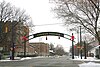 | February 7, 1991 (#90002216) | Roughly bounded by Vine, Dayton, Riverfront Plaza, and Martin Luther King Jr. Boulevard 39°24′12″N 84°33′33″W / 39.403333°N 84.559167°W / 39.403333; -84.559167 (German Village Historic District) | Hamilton | |
| 33 | Great Mound |  | October 7, 1971 (#71000633) | West of Middletown[10] 39°30′56″N 84°28′35″W / 39.515556°N 84.476250°W / 39.515556; -84.476250 (Great Mound) | Madison Township | |
| 34 | Greenwood Cemetery |  | July 22, 1994 (#94000771) | 1602 Greenwood Ave. 39°24′12″N 84°32′34″W / 39.403333°N 84.542778°W / 39.403333; -84.542778 (Greenwood Cemetery) | Hamilton | |
| 35 | Hamilton Catholic High School | 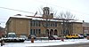 | July 24, 1986 (#86001917) | 533 Dayton St. 39°24′01″N 84°33′20″W / 39.400278°N 84.555556°W / 39.400278; -84.555556 (Hamilton Catholic High School) | Hamilton | |
| 36 | Hamilton Downtown Historic District | 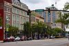 | July 18, 2016 (#16000458) | 135-245 and 250-358 High, 9-21 N. 3rd, 6-222 S. 2nd, 2-306 and 11-301 S. 3rd, 105-309 and 224-234 Court, and 311-316 Ludlow Sts. 39°23′57″N 84°33′36″W / 39.399167°N 84.560000°W / 39.399167; -84.560000 (Hamilton Downtown Historic District) | Hamilton | |
| 37 | Hamilton Historic Civic Center |  | June 29, 1995 (#94000170) | Roughly bounded by Market St., High St., Court St., and Monument Ave., including High-Main St. Bridge 39°24′04″N 84°33′53″W / 39.401111°N 84.564722°W / 39.401111; -84.564722 (Hamilton Historic Civic Center) | Hamilton | |
| 38 | Harding-Jones Paper Company District |  | May 29, 1975 (#75001330) | Both sides of S. Main St. at its junction with railroad tracks in Excello 39°28′34″N 84°25′14″W / 39.476111°N 84.420556°W / 39.476111; -84.420556 (Harding-Jones Paper Company District) | Lemon Township | |
| 39 | Herron Gymnasium |  | November 29, 1979 (#79001788) | Miami University campus 39°30′34″N 84°44′02″W / 39.509444°N 84.733889°W / 39.509444; -84.733889 (Herron Gymnasium) | Oxford | Demolished |
| 40 | James P. Hidley Cottage |  | August 18, 1980 (#80002951) | 1820 Oxford-Reily Rd., south of Oxford 39°26′05″N 84°45′31″W / 39.434722°N 84.758611°W / 39.434722; -84.758611 (James P. Hidley Cottage) | Reily Township | |
| 41 | High Street Commercial Block |  | March 3, 2004 (#04000113) | 228, 232, and 236 High St.; 216-226 High Street 39°23′59″N 84°33′39″W / 39.399722°N 84.560833°W / 39.399722; -84.560833 (High Street Commercial Block) | Hamilton | Boundary increased in May 2014 |
| 42 | Hogan-Borger Mound Archeological District |  | October 21, 1975 (#75001338) | Eastern side of Hamilton-New London Rd., north of Ross[9]: 46 39°20′41″N 84°39′34″W / 39.344722°N 84.659444°W / 39.344722; -84.659444 (Hogan-Borger Mound Archeological District) | Ross Township | |
| 43 | Hotel Manchester |  | September 10, 2014 (#14000589) | 1027 Manchester Ave. 39°31′04″N 84°24′10″W / 39.5179°N 84.4027°W / 39.5179; -84.4027 (Hotel Manchester) | Middletown | |
| 44 | Howe Tavern |  | January 30, 1976 (#76001376) | U.S. Route 27 39°34′02″N 84°48′54″W / 39.567361°N 84.815000°W / 39.567361; -84.815000 (Howe Tavern) | College Corner | |
| 45 | Matthew Hueston House |  | September 16, 1977 (#77001045) | 1320 Four Mile Creek Rd., northwest of Hamilton 39°28′00″N 84°36′21″W / 39.466667°N 84.605833°W / 39.466667; -84.605833 (Matthew Hueston House) | Hanover Township | |
| 46 | Hughes Manor |  | March 17, 1994 (#94000242) | 5894 Hamilton-Lebanon Rd. 39°26′51″N 84°25′03″W / 39.447500°N 84.417500°W / 39.447500; -84.417500 (Hughes Manor) | Monroe | |
| 47 | Hughes School |  | January 2, 1976 (#76001377) | 5994 Princeton Rd., east of Hamilton 39°23′12″N 84°25′13″W / 39.386667°N 84.420278°W / 39.386667; -84.420278 (Hughes School) | Liberty Township | |
| 48 | Hunting Lodge Farm |  | October 20, 1982 (#82001361) | Southeast of Oxford at 5349 Coulter Ln.[12] 39°31′15″N 84°43′20″W / 39.520833°N 84.722222°W / 39.520833; -84.722222 (Hunting Lodge Farm) | Oxford Township | |
| 49 | Christian Iutzi Farm |  | August 3, 1984 (#84002904) | 2180 Woodsdale Rd., south of Trenton 39°26′39″N 84°27′18″W / 39.444167°N 84.455000°W / 39.444167; -84.455000 (Christian Iutzi Farm) | Madison Township | |
| 50 | John Kennel Sr. Farm |  | August 3, 1984 (#84002906) | 5506 Kennel Rd. 39°27′42″N 84°28′31″W / 39.461667°N 84.475278°W / 39.461667; -84.475278 (John Kennel Sr. Farm) | Trenton | |
| 51 | John Kennel Jr. Farm |  | August 3, 1984 (#84002907) | 2251 Wayne-Madison Rd., south of Trenton 39°26′49″N 84°28′37″W / 39.446806°N 84.477083°W / 39.446806; -84.477083 (John Kennel Jr. Farm) | St. Clair Township | |
| 52 | Elias Kumler House | 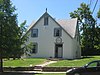 | January 3, 1980 (#80002948) | 120 S. Main St. 39°30′31″N 84°44′34″W / 39.508611°N 84.742778°W / 39.508611; -84.742778 (Elias Kumler House) | Oxford | |
| 53 | Lane's Mill Historic Buildings | 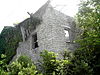 | October 3, 1980 (#80002950) | South of Oxford at 3884 Wallace Rd. 39°28′57″N 84°41′32″W / 39.4825°N 84.692222°W / 39.4825; -84.692222 (Lane's Mill Historic Buildings) | Milford Township | |
| 54 | Lane-Hooven House |  | October 25, 1973 (#73001389) | 319 N. 3rd St. 39°24′13″N 84°33′34″W / 39.403611°N 84.559444°W / 39.403611; -84.559444 (Lane-Hooven House) | Hamilton | |
| 55 | Langstroth Cottage |  | June 22, 1976 (#76001378) | 303 Patterson Ave. 39°30′23″N 84°43′49″W / 39.506389°N 84.730278°W / 39.506389; -84.730278 (Langstroth Cottage) | Oxford | |
| 56 | Main Street Commercial Historic District | 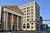 | February 22, 2014 (#14000027) | Junction of Main St. and Central Ave. 39°31′02″N 84°24′17″W / 39.517222°N 84.404722°W / 39.517222; -84.404722 (Main Street Commercial Historic District) | Middletown | |
| 57 | Henry Maltby House |  | November 29, 1979 (#79001789) | 216 E. Church St 39°30′42″N 84°44′19″W / 39.511667°N 84.738611°W / 39.511667; -84.738611 (Henry Maltby House) | Oxford | Demolished |
| 58 | Mann Mound |  | October 7, 1971 (#71000632) | Section 12 of Wayne Township, northeast of Jacksonburg[13]: 221 39°33′06″N 84°29′42″W / 39.551528°N 84.495000°W / 39.551528; -84.495000 (Mann Mound) | Wayne Township | |
| 59 | William H. McGuffey House | 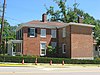 | October 15, 1966 (#66000605) | 401 E. Spring St. 39°30′25″N 84°44′10″W / 39.506944°N 84.736111°W / 39.506944; -84.736111 (William H. McGuffey House) | Oxford | |
| 60 | Miami-Erie Canal Site Historic District | 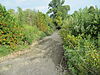 | December 18, 1978 (#78002016) | 5171-5251 Rialto Rd., west of West Chester 39°19′29″N 84°27′07″W / 39.324722°N 84.451944°W / 39.324722; -84.451944 (Miami-Erie Canal Site Historic District) | West Chester Township | |
| 61 | Mill Office and Post Office | 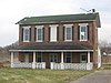 | November 1, 1984 (#84000214) | 1701 Woodsdale Rd. in Woodsdale[14] 39°25′57″N 84°28′32″W / 39.432500°N 84.475556°W / 39.432500; -84.475556 (Mill Office and Post Office) | Madison Township | |
| 62 | Morgan Township House |  | November 2, 2016 (#16000753) | 6464 Okeana Drewersburg Rd. at Okeana 39°20′54″N 84°46′00″W / 39.348333°N 84.766667°W / 39.348333; -84.766667 (Morgan Township House) | Morgan Township | |
| 63 | Morgan-Hueston House |  | October 1, 1990 (#90001495) | Ross Rd. between Mack Rd. and Woodridge Boulevard 39°18′39″N 84°30′18″W / 39.310806°N 84.50500°W / 39.310806; -84.50500 (Morgan-Hueston House) | Fairfield | |
| 64 | Notre Dame Academy and Notre Dame High School |  | February 2, 2001 (#01000048) | 926 2nd St. 39°23′27″N 84°33′52″W / 39.390833°N 84.564444°W / 39.390833; -84.564444 (Notre Dame Academy and Notre Dame High School) | Hamilton | |
| 65 | Oakland Residential Historic District | Upload image | March 20, 2023 (#100008736) | Bounded by 1st, Curtis, Woodlawn, Parkview, and Calumet Aves., Grove, Garfield, and Richmond Sts. 39°30′16″N 84°24′01″W / 39.5044°N 84.4003°W / 39.5044; -84.4003 (Oakland Residential Historic District) | Middletown | |
| 66 | Oxford Female Institute | 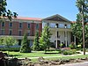 | April 26, 1976 (#76001379) | High St. and College Ave. 39°30′36″N 84°44′46″W / 39.51°N 84.746111°W / 39.51; -84.746111 (Oxford Female Institute) | Oxford | |
| 67 | Oxford Railroad Depot and Junction House |  | February 8, 1980 (#80002949) | S. Elm and W. Spring St. 39°30′27″N 84°44′51″W / 39.5075°N 84.7475°W / 39.5075; -84.7475 (Oxford Railroad Depot and Junction House) | Oxford | Depot is demolished; Junction House remains standing |
| 68 | Howell and Anna Powell Farm | Upload image | November 1, 2019 (#100004562) | 2720 Cincinnati-Brookville Rd. Coordinates missing | Fairfield | Also listed as "Powell-Decker Farm". |
| 69 | Pugh's Mill Covered Bridge |  | June 5, 1975 (#75001336) | 1 mi (1.6 km) north of Oxford off State Route 732 39°31′26″N 84°44′06″W / 39.523889°N 84.735°W / 39.523889; -84.735 (Pugh's Mill Covered Bridge) | Oxford Township | |
| 70 | Rentschler House |  | April 21, 1983 (#83001948) | 643 Dayton St. 39°23′59″N 84°33′14″W / 39.399722°N 84.553889°W / 39.399722; -84.553889 (Rentschler House) | Hamilton | |
| 71 | Roberts Mound |  | March 27, 1975 (#75001329) | Eastern side of Gates Rd., west of Millville[9]: 45 39°23′53″N 84°43′10″W / 39.398056°N 84.719444°W / 39.398056; -84.719444 (Roberts Mound) | Reily Township | |
| 72 | D.S. Rose Mound | 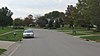 | May 28, 1975 (#75001333) | Southwestern quarter of the northeastern quarter of Section 20 of Liberty Township, ¼ mile northwest of Poasttown[9]: 55 39°23′45″N 84°23′36″W / 39.395750°N 84.393333°W / 39.395750; -84.393333 (D.S. Rose Mound) | Liberty Township | Demolished by the owner without a chance for archaeological excavation[15] |
| 73 | Ross Trails Adena Circle | Upload image | October 10, 1975 (#75001339) | Grounds of the former Ross Trails Girl Scout Camp[16] | Ross Township | |
| 74 | Rossville Historic District |  | October 6, 1975 (#75001332) | Roughly bounded by B, E, Main, and Amberly Dr. 39°24′00″N 84°34′14″W / 39.4°N 84.570556°W / 39.4; -84.570556 (Rossville Historic District) | Hamilton | |
| 75 | St. Stephen Church and Rectory | 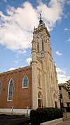 | July 29, 1982 (#82003549) | 224 Dayton St. 39°24′07″N 84°33′36″W / 39.401944°N 84.56°W / 39.401944; -84.56 (St. Stephen Church and Rectory) | Hamilton | |
| 76 | Peter Schrock Jr. Farm | 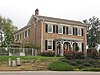 | November 1, 1984 (#84000210) | Edgewood Dr. 39°28′39″N 84°28′14″W / 39.477500°N 84.470556°W / 39.477500; -84.470556 (Peter Schrock Jr. Farm) | Trenton | |
| 77 | John Scott Barn and Granary | 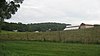 | October 4, 2005 (#05001142) | 3681 Hamilton-New London Rd., east of Shandon 39°19′41″N 84°41′39″W / 39.328056°N 84.694167°W / 39.328056; -84.694167 (John Scott Barn and Granary) | Ross Township | |
| 78 | Shaw Farm |  | July 24, 1974 (#74001405) | 3357 Cincinnati-Brookville Rd., west of Ross 39°18′25″N 84°40′22″W / 39.306944°N 84.672778°W / 39.306944; -84.672778 (Shaw Farm) | Ross Township | |
| 79 | Shuler & Benninghofen Woolen Mill | Upload image | September 5, 2023 (#100009299) | 2350 Pleasant Ave. 39°22′23″N 84°33′26″W / 39.3730°N 84.5572°W / 39.3730; -84.5572 (Shuler & Benninghofen Woolen Mill) | Hamilton | |
| 80 | Sigma Alpha Epsilon Chapter House of Miami University |  | February 8, 2005 (#05000022) | 310 Tallawanda Rd. 39°30′51″N 84°44′06″W / 39.514167°N 84.735°W / 39.514167; -84.735 (Sigma Alpha Epsilon Chapter House of Miami University) | Oxford | |
| 81 | Dan F. Snider Ford Dealership Building |  | December 11, 2014 (#14001050) | 101 N. Main St. 39°31′06″N 84°24′12″W / 39.518333°N 84.403333°W / 39.518333; -84.403333 (Dan F. Snider Ford Dealership Building) | Middletown | |
| 82 | South Main Street District |  | March 21, 1978 (#78002015) | S. Main St. 39°30′45″N 84°24′33″W / 39.5125°N 84.409167°W / 39.5125; -84.409167 (South Main Street District) | Middletown | |
| 83 | Spread Eagle Tavern-James D. Conrey House |  | October 24, 2003 (#03001100) | 9797 Cincinnati-Columbus Rd., north of Cincinnati 39°18′30″N 84°23′05″W / 39.308333°N 84.384722°W / 39.308333; -84.384722 (Spread Eagle Tavern-James D. Conrey House) | West Chester Township | |
| 84 | Symmes Mission Chapel | 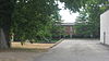 | June 12, 1980 (#80002946) | 5139 Pleasant Ave. 39°20′22″N 84°33′37″W / 39.339444°N 84.560278°W / 39.339444; -84.560278 (Symmes Mission Chapel) | Fairfield | |
| 85 | Thomas Select School | 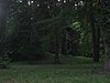 | April 11, 1977 (#77001046) | 3637 Millville-Shandon Rd. at Shandon 39°19′41″N 84°42′53″W / 39.327917°N 84.714861°W / 39.327917; -84.714861 (Thomas Select School) | Morgan Township | |
| 86 | John B. Tytus House | 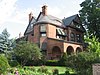 | May 27, 1975 (#75001335) | 300 S. Main St. 39°30′47″N 84°23′49″W / 39.513056°N 84.396944°W / 39.513056; -84.396944 (John B. Tytus House) | Middletown | |
| 87 | Union Township Works II |  | October 7, 1971 (#71000635) | Southern side of Dimmick Rd. on the eastern side of Sharon Creek[9]: 48 39°18′28″N 84°22′03″W / 39.307778°N 84.367500°W / 39.307778; -84.367500 (Union Township Works II) | West Chester Township | Near Pisgah |
| 88 | Unzicker-Cook House | 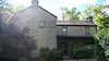 | July 24, 1974 (#74001404) | 2975 Oxford-Middletown Rd., northeast of Oxford 39°31′59″N 84°39′27″W / 39.533056°N 84.657500°W / 39.533056; -84.657500 (Unzicker-Cook House) | Morgan Township | |
| 89 | John Vaughan House |  | May 29, 1975 (#75001340) | 3756 Hamilton-New London Rd. at Shandon 39°19′35″N 84°42′38″W / 39.326250°N 84.710556°W / 39.326250; -84.710556 (John Vaughan House) | Morgan Township | |
| 90 | Voice of America Bethany Relay Station |  | November 28, 2006 (#06001081) | 8070 Tylersville Rd., north of West Chester 39°21′18″N 84°21′24″W / 39.355°N 84.356667°W / 39.355; -84.356667 (Voice of America Bethany Relay Station) | West Chester Township | |
| 91 | Western Female Seminary | 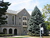 | September 17, 1979 (#09000083) | Junction of U.S. Route 27 and State Route 73, Western College, Miami University 39°30′14″N 84°43′36″W / 39.503889°N 84.726667°W / 39.503889; -84.726667 (Western Female Seminary) | Oxford | |
| 92 | Williamson Mound Archeological District |  | May 29, 1975 (#75001334) | East of U.S. Route 42 on the western edge of the Wetherington Golf and Country Club[9]: 54 39°22′01″N 84°23′04″W / 39.366944°N 84.384444°W / 39.366944; -84.384444 (Williamson Mound Archeological District) | West Chester Township |
Former listings
| [3] | Name on the Register | Image | Date listed | Date removed | Location | City or town | Description |
|---|---|---|---|---|---|---|---|
| 1 | Fisher Hall | 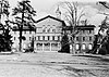 | May 6, 1971 (#71000634) | July 1, 1978 | Miami University campus | Oxford | Demolished in July 1978.[17] |
| 2 | Phillip Hughes House | Upload image | April 11, 1977 (#77001584) | July 27, 1977 | East of Hamilton at the junction of State Routes 4 and 747 39°25′39″N 84°27′00″W / 39.4276°N 84.45°W / 39.4276; -84.45 (Phillip Hughes House) | Hamilton | Demolished in July 1977. |
| 3 | Pleasant Run Mounds | Upload image | Unavailable (#73002287) | 1975 | Address Restricted | Fairfield |
See also
Wikimedia Commons has media related to National Register of Historic Places in Butler County, Ohio.
- List of National Historic Landmarks in Ohio
- Listings in neighboring counties: Dearborn (IN), Franklin (IN), Hamilton, Montgomery, Preble, Union (IN), Warren
- National Register of Historic Places listings in Ohio
References
- ^ The latitude and longitude information provided in this table was derived originally from the National Register Information System, which has been found to be fairly accurate for about 99% of listings. Some locations in this table may have been corrected to current GPS standards.
- ^ National Park Service, United States Department of the Interior, "National Register of Historic Places: Weekly List Actions", retrieved June 7, 2024.
- ^ a b Numbers represent an alphabetical ordering by significant words. Various colorings, defined here, differentiate National Historic Landmarks and historic districts from other NRHP buildings, structures, sites or objects.
- ^ "National Register Information System". National Register of Historic Places. National Park Service. March 13, 2009.
- ^ The eight-digit number below each date is the number assigned to each location in the National Register Information System database, which can be viewed by clicking the number.
- ^ Simmons, D. "Ohio Historic Inventory: Augspurger Paper Company Rowhouse 1". Columbus: Ohio Historical Society, 1984-08.
- ^ Simmons, D. "Ohio Historic Inventory: Augspurger Paper Company Rowhouse 2". Columbus: Ohio Historical Society, 1984-08.
- ^ Simmons, D. "Ohio Historic Inventory: Augspurger, Samuel, House". Columbus: Ohio Historical Society, 1984-08.
- ^ a b c d e f g Koleszar, Stephen C. An Archaeological Survey of Southwestern Ohio. Columbus: Ohio Historical Society, 1970.
- ^ a b Location derived from Mills, William C. Archeological Atlas of Ohio. Columbus: Ohio State Archeological and Historical Society, 1914, page 9 and plate 9. The NRIS lists the site as "Address Restricted".
- ^ Location derived from its Ohio Historic Inventory form; the NRIS lists the site as "Address Restricted".
- ^ Curry, Lucy. "Ohio Historic Inventory: Hunting Lodge Farm". Columbus: Ohio Historical Society, 1978-07-03.
- ^ MacLean, J. P., The Mound Builders: Being an Account of a Remarkable People that Once Inhabited the Valleys of the Ohio and Mississippi, Together with an Investigation Into the Archæology of Butler County, O. Cincinnati: Clarke, 1879.
- ^ Simmons, D. "Ohio Historic Inventory: Augspurger Company Office, Store and Post Office". Columbus: Ohio Historical Society, 1984-08.
- ^ Ohio Archaeologist 42/43 (1992), 23.
- ^ National Lead Company of Ohio. "Study of Radioactive Waste Storage Areas at the Feed Materials Production Center". Department of Energy, 1977-04-25, 6.
- ^ "Wrecking Ball Gets Best Of Fisher Hall". The Cincinnati Enquirer. July 23, 1978. p. E2. Retrieved August 12, 2022 – via Newspapers.com.
External links
- Ohio Historic Inventory forms for Butler County
- v
- t
- e
by county
- Adams
- Allen
- Ashland
- Ashtabula
- Athens
- Auglaize
- Belmont
- Brown
- Butler
- Carroll
- Champaign
- Clark
- Clermont
- Clinton
- Columbiana
- Coshocton
- Crawford
- Cuyahoga
- Darke
- Defiance
- Delaware
- Erie
- Fairfield
- Fayette
- Franklin
- Fulton
- Gallia
- Geauga
- Greene
- Guernsey
- Hamilton
- Hancock
- Hardin
- Harrison
- Henry
- Highland
- Hocking
- Holmes
- Huron
- Jackson
- Jefferson
- Knox
- Lake
- Lawrence
- Licking
- Logan
- Lorain
- Lucas
- Madison
- Mahoning
- Marion
- Medina
- Meigs
- Mercer
- Miami
- Monroe
- Montgomery
- Morgan
- Morrow
- Muskingum
- Noble
- Ottawa
- Paulding
- Perry
- Pickaway
- Pike
- Portage
- Preble
- Putnam
- Richland
- Ross
- Sandusky
- Scioto
- Seneca
- Shelby
- Stark
- Summit
- Trumbull
- Tuscarawas
- Union
- Van Wert
- Vinton
- Warren
- Washington
- Wayne
- Williams
- Wood
- Wyandot


