National Register of Historic Places listings in Jackson County, Ohio

This is a list of the National Register of Historic Places listings in Jackson County, Ohio.
This is intended to be a complete list of the properties and districts on the National Register of Historic Places in Jackson County, Ohio, United States. The locations of National Register properties and districts for which the latitude and longitude coordinates are included below, may be seen in an online map.[1]
There are 14 properties and districts listed on the National Register in the county.
This National Park Service list is complete through NPS recent listings posted June 28, 2024.[2]
Map all coordinates using OpenStreetMap
Download coordinates as:
- KML
- GPX (all coordinates)
- GPX (primary coordinates)
- GPX (secondary coordinates)
Current listings
| [3] | Name on the Register[4] | Image | Date listed[5] | Location | City or town | Description |
|---|---|---|---|---|---|---|
| 1 | Battle of Berlin Heights Engagement Site | Upload image | July 5, 2018 (#100002645) | Eastern half of the northwestern quarter and western half of the northeastern quarter of Section 19, Township 7 North, Range 17 West 39°04′52″N 82°32′17″W / 39.0811°N 82.5381°W / 39.0811; -82.5381 (Battle of Berlin Heights Engagement Site) | Milton Township | Site of a Civil War battle, July 17, 1863. |
| 2 | Buckeye Furnace |  | November 10, 1970 (#70000503) | Buckeye Furnace Road 39°03′23″N 82°27′26″W / 39.056389°N 82.457222°W / 39.056389; -82.457222 (Buckeye Furnace) | Buckeye | |
| 3 | Buckeye Furnace Covered Bridge |  | February 24, 1975 (#75001442) | 3 miles southeast of Wellston 39°03′16″N 82°27′31″W / 39.054583°N 82.458611°W / 39.054583; -82.458611 (Buckeye Furnace Covered Bridge) | Buckeye | |
| 4 | Byer Covered Bridge |  | October 21, 1975 (#75001441) | Byers-Winters Road 39°10′46″N 82°37′53″W / 39.179444°N 82.631389°W / 39.179444; -82.631389 (Byer Covered Bridge) | Byer | |
| 5 | Clutts House |  | November 26, 1980 (#80003105) | 16 E. Broadway St. 39°07′25″N 82°32′04″W / 39.123611°N 82.534444°W / 39.123611; -82.534444 (Clutts House) | Wellston | |
| 6 | Gibson House | 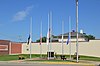 | December 5, 1985 (#85003045) | 187 Main St. 39°03′10″N 82°38′19″W / 39.052778°N 82.638611°W / 39.052778; -82.638611 (Gibson House) | Jackson | |
| 7 | Johnson Road Covered Bridge |  | August 23, 1984 (#84003749) | Johnson Rd., SW of Petersburg 38°57′31″N 82°47′16″W / 38.958611°N 82.787778°W / 38.958611; -82.787778 (Johnson Road Covered Bridge) | Petersburg | |
| 8 | Keystone Furnace | 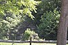 | March 18, 1982 (#82003600) | Keystone Rd. 39°00′39″N 82°27′06″W / 39.010833°N 82.451667°W / 39.010833; -82.451667 (Keystone Furnace) | Keystone | |
| 9 | Leo Petroglyph |  | November 10, 1970 (#70000501) | West of Leo 39°08′59″N 82°40′33″W / 39.149722°N 82.675833°W / 39.149722; -82.675833 (Leo Petroglyph) | Leo | |
| 10 | Miner's Supply Store | 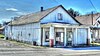 | November 1, 1977 (#77001069) | Main and 2nd Sts. 39°06′48″N 82°36′38″W / 39.113333°N 82.610556°W / 39.113333; -82.610556 (Miner's Supply Store) | Coalton | |
| 11 | Morgan Mansion |  | February 16, 1979 (#79001867) | Broadway and Pennsylvania Aves. 39°07′25″N 82°31′59″W / 39.123611°N 82.533056°W / 39.123611; -82.533056 (Morgan Mansion) | Wellston | |
| 12 | Oak Hill Welsh Congregational Church |  | May 23, 1978 (#78002090) | 412 E. Main St. 38°53′44″N 82°34′09″W / 38.895556°N 82.569167°W / 38.895556; -82.569167 (Oak Hill Welsh Congregational Church) | Oak Hill | |
| 13 | Scioto Grange No. 1234 |  | February 9, 2005 (#05000030) | 255 Cove Rd. 39°00′49″N 82°44′52″W / 39.013611°N 82.747778°W / 39.013611; -82.747778 (Scioto Grange No. 1234) | Jackson | |
| 14 | Harvey Wells House |  | April 14, 2009 (#09000211) | 403 E. A St. 39°07′27″N 82°31′49″W / 39.124222°N 82.530361°W / 39.124222; -82.530361 (Harvey Wells House) | Wellston |
See also
Wikimedia Commons has media related to National Register of Historic Places in Jackson County, Ohio.
- List of National Historic Landmarks in Ohio
- Listings in neighboring counties: Gallia, Lawrence, Pike, Ross, Scioto, Vinton
- National Register of Historic Places listings in Ohio
References
- ^ The latitude and longitude information provided in this table was derived originally from the National Register Information System, which has been found to be fairly accurate for about 99% of listings. Some locations in this table may have been corrected to current GPS standards.
- ^ National Park Service, United States Department of the Interior, "National Register of Historic Places: Weekly List Actions", retrieved June 28, 2024.
- ^ Numbers represent an alphabetical ordering by significant words. Various colorings, defined here, differentiate National Historic Landmarks and historic districts from other NRHP buildings, structures, sites or objects.
- ^ "National Register Information System". National Register of Historic Places. National Park Service. April 24, 2008.
- ^ The eight-digit number below each date is the number assigned to each location in the National Register Information System database, which can be viewed by clicking the number.
- v
- t
- e
by county
- Adams
- Allen
- Ashland
- Ashtabula
- Athens
- Auglaize
- Belmont
- Brown
- Butler
- Carroll
- Champaign
- Clark
- Clermont
- Clinton
- Columbiana
- Coshocton
- Crawford
- Cuyahoga
- Darke
- Defiance
- Delaware
- Erie
- Fairfield
- Fayette
- Franklin
- Fulton
- Gallia
- Geauga
- Greene
- Guernsey
- Hamilton
- Hancock
- Hardin
- Harrison
- Henry
- Highland
- Hocking
- Holmes
- Huron
- Jackson
- Jefferson
- Knox
- Lake
- Lawrence
- Licking
- Logan
- Lorain
- Lucas
- Madison
- Mahoning
- Marion
- Medina
- Meigs
- Mercer
- Miami
- Monroe
- Montgomery
- Morgan
- Morrow
- Muskingum
- Noble
- Ottawa
- Paulding
- Perry
- Pickaway
- Pike
- Portage
- Preble
- Putnam
- Richland
- Ross
- Sandusky
- Scioto
- Seneca
- Shelby
- Stark
- Summit
- Trumbull
- Tuscarawas
- Union
- Van Wert
- Vinton
- Warren
- Washington
- Wayne
- Williams
- Wood
- Wyandot

Municipalities and communities of Jackson County, Ohio, United States | ||
|---|---|---|
County seat: Jackson | ||
| Cities |  | |
| Villages | ||
| Townships | ||
| Unincorporated communities |
| |
| ||


