Rural Municipality of Laurier No. 38
Rural municipality in Saskatchewan, Canada
Rural municipality in Saskatchewan, Canada
49°25′37″N 104°14′20″W / 49.427°N 104.239°W / 49.427; -104.239[1][3]
(2016)[4]
(2021)[4]
S0C 2G0
The Rural Municipality of Laurier No. 38 (2021 population: 253) is a rural municipality (RM) in the Canadian province of Saskatchewan within Census Division No. 2 and SARM Division No. 2. it is located in the southeast portion of the province.
History
The RM of Laurier No. 38 incorporated as a rural municipality on December 13, 1909.[2]
- Heritage properties
There are two historical buildings located within the RM.
- Soda Lake School - Constructed in 1914, as a one room school the building now houses the Soda Lake Community Centre in Soda Lake. The school operated from 1914 until 1953.[5]
- Souris Valley Church - Constructed in 1907 as a Catholic church St. Germaine Parish of the Archdiocese of St. Boniface the church in Souris Valley. The church closed in 1970 and the building has since been operated as the Souris Valley Co-operative Memorial Club. The building has also been called the St. Germaine Roman Catholic Church.[6]
Geography
Communities and localities
The following urban municipalities are surrounded by the RM.
The following unincorporated communities are within the RM.
- Localities
- Dandonneau
- Neptune
- Souris Valley
Brooking, a ghost town, is also within the RM.
Demographics
In the 2021 Census of Population conducted by Statistics Canada, the RM of Laurier No. 38 had a population of 253 living in 95 of its 110 total private dwellings, a change of -14.5% from its 2016 population of 296. With a land area of 816.25 km2 (315.16 sq mi), it had a population density of 0.3/km2 (0.8/sq mi) in 2021.[9]
In the 2021 Census of Population, the RM of Laurier No. 38 recorded a population of 253 living in 105 of its 115 total private dwellings, a -7.8% change from its 2011 population of 321. With a land area of 840.4 km2 (324.5 sq mi), it had a population density of 0.4/km2 (0.9/sq mi) in 2016.[4]
Government
The RM of Laurier No. 38 is governed by an elected municipal council and an appointed administrator that meets on the second Tuesday of every month.[3] The reeve of the RM is Alan Krausher while its Administrator is Sam Kalmbach.[3] The RM's office is located in Radville.[3]
Transportation
The Radville Airport is located within the municipality.
Gallery
-
 Mayville School site
 -
 Liberator School site
 -
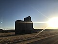 The grain elevator in Brooking
 -
 Allstine School site
 -
 Rural church
 -
 Green Valley School site
 -
 Grain elevator and railway tracks in Brooking
 -
 St. Germaine Parish plaque
 -
 Green Valley School site


References
- ^ "Pre-packaged CSV files - CGN, Canada/Province/Territory (cgn_sk_csv_eng.zip)". Government of Canada. July 24, 2019. Retrieved May 23, 2020.
- ^ a b "Rural Municipality Incorporations (Alphabetical)". Saskatchewan Ministry of Municipal Affairs. Archived from the original on April 21, 2011. Retrieved May 9, 2020.
- ^ a b c d "Municipality Details: RM of Laurier No. 38". Government of Saskatchewan. Retrieved May 21, 2020.
- ^ a b c "Population and dwelling counts, for Canada, provinces and territories, and census subdivisions (municipalities), 2016 and 2011 censuses – 100% data (Saskatchewan)". Statistics Canada. February 8, 2017. Retrieved May 1, 2020.
- ^ Soda Lake School
- ^ Souris Valley Church
- ^ "Saskatchewan Census Population" (PDF). Saskatchewan Bureau of Statistics. Archived from the original (PDF) on September 24, 2015. Retrieved May 9, 2020.
- ^ "Saskatchewan Census Population". Saskatchewan Bureau of Statistics. Retrieved May 9, 2020.
- ^ "Population and dwelling counts: Canada, provinces and territories, census divisions and census subdivisions (municipalities), Saskatchewan". Statistics Canada. February 9, 2022. Retrieved April 13, 2022.
- v
- t
- e
Subdivisions of Saskatchewan
- Aberdeen
- Abernethy
- Antelope Park
- Antler
- Arborfield
- Argyle
- Arlington
- Arm River
- Auvergne
- Baildon
- Barrier Valley
- Battle River
- Bayne
- Beaver River
- Bengough
- Benson
- Big Arm
- Biggar
- Big Quill
- Big River
- Big Stick
- Birch Hills
- Bjorkdale
- Blaine Lake
- Blucher
- Bone Creek
- Bratt's Lake
- Britannia
- Brock
- Brokenshell
- Browning
- Buchanan
- Buckland
- Buffalo
- Calder
- Caledonia
- Cambria
- Cana
- Canaan
- Canwood
- Carmichael
- Caron
- Chaplin
- Chester
- Chesterfield
- Churchbridge
- Clayton
- Clinworth
- Coalfields
- Colonsay
- Connaught
- Corman Park
- Cote
- Coteau
- Coulee
- Craik
- Cupar
- Cut Knife
- Cymri
- Deer Forks
- Douglas
- Duck Lake
- Dufferin
- Dundurn
- Eagle Creek
- Edenwold
- Elcapo
- Eldon
- Elfros
- Elmsthorpe
- Emerald
- Enfield
- Enniskillen
- Enterprise
- Estevan
- Excel
- Excelsior
- Eyebrow
- Eye Hill
- Fertile Belt
- Fertile Valley
- Fillmore
- Fish Creek
- Flett's Springs
- Foam Lake
- Fox Valley
- Francis
- Frenchman Butte
- Frontier
- Garden River
- Garry
- Glen Bain
- Glen McPherson
- Glenside
- Golden West
- Good Lake
- Grandview
- Grant
- Grass Lake
- Grassy Creek
- Gravelbourg
- Grayson
- Great Bend
- Griffin
- Gull Lake
- Happyland
- Happy Valley
- Harris
- Hart Butte
- Hazel Dell
- Hazelwood
- Heart's Hill
- Hillsborough
- Hillsdale
- Hoodoo
- Hudson Bay
- Humboldt
- Huron
- Indian Head
- Insinger
- Invergordon
- Invermay
- Ituna Bon Accord
- Kellross
- Kelvington
- Keys
- Key West
- Kindersley
- King George
- Kingsley
- Kinistino
- Lacadena
- Lac Pelletier
- Laird
- Lajord
- Lake Alma
- Lake Johnston
- Lakeland
- Lake Lenore
- Lake of the Rivers
- Lakeside
- Lakeview
- Langenburg
- Last Mountain Valley
- Laurier
- Lawtonia
- Leask
- Leroy
- Lipton
- Livingston
- Lomond
- Lone Tree
- Longlaketon
- Loon Lake
- Loreburn
- Lost River
- Lumsden
- Manitou Lake
- Mankota
- Maple Bush
- Maple Creek
- Mariposa
- Marquis
- Marriott
- Martin
- Maryfield
- Mayfield
- McCraney
- McKillop
- McLeod
- Meadow Lake
- Medstead
- Meeting Lake
- Meota
- Mervin
- Milden
- Milton
- Miry Creek
- Monet
- Montmartre
- Montrose
- Moose Creek
- Moose Jaw
- Moose Mountain
- Moose Range
- Moosomin
- Morris
- Morse
- Mountain View
- Mount Hope
- Mount Pleasant
- Newcombe
- Nipawin
- North Battleford
- North Qu'Appelle
- Norton
- Oakdale
- Old Post
- Orkney
- Paddockwood
- Parkdale
- Paynton
- Pense
- Perdue
- Piapot
- Pinto Creek
- Pittville
- Pleasantdale
- Pleasant Valley
- Ponass Lake
- Poplar Valley
- Porcupine
- Prairiedale
- Prairie Rose
- Preeceville
- Prince Albert
- Progress
- Reciprocity
- Redberry
- Redburn
- Reford
- Reno
- Riverside
- Rocanville
- Rodgers
- Rosedale
- Rosemount
- Rosthern
- Round Hill
- Round Valley
- Rudy
- Saltcoats
- Sarnia
- Saskatchewan Landing
- Sasman
- Scott
- Senlac
- Shamrock
- Shellbrook
- Sherwood
- Silverwood
- Sliding Hills
- Snipe Lake
- Souris Valley
- South Qu'Appelle
- Spalding
- Spiritwood
- Spy Hill
- St. Andrews
- Stanley
- Star City
- St. Louis
- St. Peter
- St. Philips
- Stonehenge
- Storthoaks
- Surprise Valley
- Sutton
- Swift Current
- Tecumseh
- Terrell
- The Gap
- Three Lakes
- Tisdale
- Torch River
- Touchwood
- Tramping Lake
- Tullymet
- Turtle River
- Usborne
- Val Marie
- Vanscoy
- Victory
- Viscount
- Wallace
- Walpole
- Waverley
- Wawken
- Webb
- Wellington
- Weyburn
- Wheatlands
- Whiska Creek
- White Valley
- Willner
- Willow Bunch
- Willow Creek
- Willowdale
- Wilton
- Winslow
- Wise Creek
- Wolseley
- Wolverine
- Wood Creek
- Wood River
- Wreford
- Culture
- Economy
- First Nations
- Geography
- Government
- History
- Regions
- Tourist attractions
 Category
 Canada portal
 WikiProject


