Grade I listed buildings in Herefordshire

Map all coordinates using OpenStreetMap
Download coordinates as:
- KML
- GPX (all coordinates)
- GPX (primary coordinates)
- GPX (secondary coordinates)
There are over 9,000 Grade I listed buildings in England. This page is a list of these buildings in the county of Herefordshire.
County of Herefordshire
| Name | Location | Type | Completed [note 1] | Date designated | Grid ref.[note 2] Geo-coordinates | Entry number [note 3] | Image |
|---|---|---|---|---|---|---|---|
| Church of St Mary | Abbey Dore | Abbey | Late 12th century to Early 13th century | 26 January 1962 | SO3871730401 51°58′07″N 2°53′36″W / 51.968688°N 2.89345°W / 51.968688; -2.89345 (Church of St Mary) | 1099794 |  More images |
| Wigmore Abbey Grange Gatehouse | Adforton | Gatehouse | 14th century | 11 June 1959 | SO4101271270 52°20′11″N 2°52′02″W / 52.336326°N 2.867159°W / 52.336326; -2.867159 (Wigmore Abbey Grange Gatehouse) | 1349753 |  |
| Wigmore Abbey Grange Outbuilding | Adforton | Gatehouse | 14th century with later alterations | 11 June 1959 | SO4092371320 52°20′12″N 2°52′07″W / 52.336766°N 2.868474°W / 52.336766; -2.868474 (Wigmore Abbey Grange Outbuilding) | 1082061 |  Upload Photo |
| Wigmore Abbey ruins | Adforton | Abbey | Late 12th century | 11 June 1959 | SO4106771308 52°20′12″N 2°51′59″W / 52.336674°N 2.866359°W / 52.336674; -2.866359 (Wigmore Abbey ruins) | 1179921 |  More images |
| Wigmore Abbey Grange Storage Building | Adforton | Storehouse | 14th century with later alterations | 11 June 1959 | SO4090571309 52°20′12″N 2°52′07″W / 52.336665°N 2.868736°W / 52.336665; -2.868736 (Wigmore Abbey Grange Storage Building) | 1179912 | Upload Photo |
| The Grange | Adforton | Grange | 12th century | 11 June 1959 | SO4104171274 52°20′11″N 2°52′00″W / 52.336365°N 2.866734°W / 52.336365; -2.866734 (The Grange) | 1082057 | 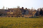 More images |
| Church of St Mary | Almeley | Parish Church | Later alterations | 2 September 1966 | SO3327451501 52°09′28″N 2°58′36″W / 52.157735°N 2.976797°W / 52.157735; -2.976797 (Church of St Mary) | 1081702 |  More images |
| Church of St John the Baptist and St Alkmund | Aymestrey | Parish Church | 12th century | 11 June 1959 | SO4260265130 52°16′53″N 2°50′34″W / 52.281301°N 2.842777°W / 52.281301; -2.842777 (Church of St John the Baptist and St Alkmund) | 1082113 |  More images |
| Church of St Peter | Birley, Birley with Upper Hill | Parish Church | 13th century | 2 September 1966 | SO4535653354 52°10′33″N 2°48′02″W / 52.175723°N 2.800506°W / 52.175723; -2.800506 (Church of St Peter) | 1081970 |  More images |
| Bell Tower | Bosbury | Bell Tower | 13th century | 26 March 1986 | SO6955843420 52°05′18″N 2°26′45″W / 52.088285°N 2.445711°W / 52.088285; -2.445711 (Bell Tower) | 1349189 |  More images |
| Church of Holy Trinity | Bosbury | Parish Church | Early 12th century | 6 March 1972 | SO6954943451 52°05′19″N 2°26′45″W / 52.088563°N 2.445845°W / 52.088563; -2.445845 (Church of Holy Trinity) | 1098890 |  More images |
| Brampton Bryan Castle | Brampton Bryan | Castle | Early 14th century | 11 June 1959 | SO3703072577 52°20′51″N 2°55′33″W / 52.347632°N 2.925839°W / 52.347632; -2.925839 (Brampton Bryan Castle) | 1082066 | 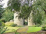 More images |
| Church of St Barnabas | Brampton Bryan | Bell Tower | 19th century | 11 June 1959 | SO3704872514 52°20′49″N 2°55′32″W / 52.347067°N 2.925562°W / 52.347067; -2.925562 (Church of St Barnabas) | 1179943 |  More images |
| Ruins of Hall about 10 yards North of Brampton Bryan Castle | Brampton Bryan | Hall House | Early 14th century | 11 June 1959 | SO3703072596 52°20′52″N 2°55′33″W / 52.347802°N 2.925842°W / 52.347802; -2.925842 (Ruins of Hall about 10 yards North of Brampton Bryan Castle) | 1301697 |  |
| Church of St Andrew | Bridge Sollers | Parish Church | 12th century | 2 September 1966 | SO4147842615 52°04′44″N 2°51′19″W / 52.078786°N 2.855358°W / 52.078786; -2.855358 (Church of St Andrew) | 1157590 |  More images |
| Ruins of Wilton Castle and House attached to South | Wilton, Bridstow | Castle | c. 1300 | 18 May 1953 | SO5900624371 51°54′59″N 2°35′51″W / 51.916348°N 2.597422°W / 51.916348; -2.597422 (Ruins of Wilton Castle and House attached to South) | 1214349 |  More images |
| Wilton Bridge and Sundial (that Part in Bridstow Civil Parish) | Wilton, Bridstow | Bridge | 1597 | 22 March 1973 | SO5898024215 51°54′54″N 2°35′52″W / 51.914943°N 2.597782°W / 51.914943; -2.597782 (Wilton Bridge and Sundial (that Part in Bridstow Civil Parish)) | 1288736 |  More images |
| Brinsop Court | Brinsop | House | 14th century | 20 February 1953 | SO4460345792 52°06′28″N 2°48′37″W / 52.107668°N 2.810281°W / 52.107668; -2.810281 (Brinsop Court) | 1349793 |  More images |
| Church of St George | Brinsop | Parish Church | 12th century | 2 September 1966 | SO4423344791 52°05′55″N 2°48′56″W / 52.098633°N 2.815519°W / 52.098633; -2.815519 (Church of St George) | 1081971 |  More images |
| Church of St Mary | Monnington on Wye, Brobury with Monnington on Wye | Parish Church | 15th century | 2 September 1966 | SO3735543325 52°05′05″N 2°54′56″W / 52.084717°N 2.915643°W / 52.084717; -2.915643 (Church of St Mary) | 1349851 | 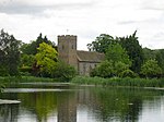 More images |
| Church of All Saints | Brockhampton | Parish Church | 1901-1902 | 25 February 1966 | SO5941332147 51°59′11″N 2°35′33″W / 51.986286°N 2.592426°W / 51.986286; -2.592426 (Church of All Saints) | 1349021 |  More images |
| Gatehouse South West of Lower Brockhampton House | Brockhampton | Gatehouse | Late 15th century | 12 April 1973 | SO6874155979 52°12′04″N 2°27′32″W / 52.201147°N 2.458794°W / 52.201147; -2.458794 (Gatehouse South West of Lower Brockhampton House) | 1082376 |  More images |
| Lower Brockhampton House | Brockhampton | Cross Wing House | Late 14th century or early 15th century | 9 April 1952 | SO6875356002 52°12′05″N 2°27′31″W / 52.201355°N 2.45862°W / 52.201355; -2.45862 (Lower Brockhampton House) | 1176676 |  More images |
| Church of St Peter | Bromyard, Bromyard and Winslow | Church | Late 12th century | 25 October 1951 | SO6554154842 52°11′27″N 2°30′20″W / 52.190734°N 2.505498°W / 52.190734; -2.505498 (Church of St Peter) | 1307758 |  More images |
| Church of St John the Baptist | Byford | Parish Church | 12th century | 2 September 1966 | SO3971742917 52°04′53″N 2°52′52″W / 52.081312°N 2.881105°W / 52.081312; -2.881105 (Church of St John the Baptist) | 1349866 |  More images |
| Church of St Lawrence | Canon Pyon | Parish Church | 13th century | 2 September 1966 | SO4500849176 52°08′17″N 2°48′18″W / 52.13813°N 2.804916°W / 52.13813; -2.804916 (Church of St Lawrence) | 1081974 |  More images |
| Church of St Michael | Castle Frome | Parish Church | 12th century | 6 March 1967 | SO6675845868 52°06′36″N 2°29′13″W / 52.110132°N 2.486814°W / 52.110132; -2.486814 (Church of St Michael) | 1098869 |  More images |
| Church of All Saints | Clehonger | Parish Church | 12th century | 26 January 1967 | SO4654637949 52°02′14″N 2°46′50″W / 52.037353°N 2.780683°W / 52.037353; -2.780683 (Church of All Saints) | 1301135 |  More images |
| Clifford Castle and Barbican | Clifford | Castle | Late 13th century | 17 January 1949 | SO2434945677 52°06′15″N 3°06′21″W / 52.104231°N 3.105938°W / 52.104231; -3.105938 (Clifford Castle and Barbican) | 1167903 |  More images |
| Church of St Mary | Credenhill | Parish Church | 12th century | 27 January 1967 | SO4503043882 52°05′26″N 2°48′13″W / 52.090541°N 2.803738°W / 52.090541; -2.803738 (Church of St Mary) | 1168027 |  More images |
| Church of St Michael | Croft Castle, Croft and Yarpole | Parish Church | Mid 14th century | 11 June 1959 | SO4498665427 52°17′03″N 2°48′28″W / 52.284216°N 2.807884°W / 52.284216; -2.807884 (Church of St Michael) | 1166506 |  More images |
| Croft Castle | Croft and Yarpole | Country House | Late 16th century to early 17th century | 8 November 1956 | SO4494365435 52°17′03″N 2°48′31″W / 52.284283°N 2.808516°W / 52.284283; -2.808516 (Croft Castle) | 1166451 |  More images |
| Tower about 15 metres South of Church of St Leonard | Yarpole, Croft and Yarpole | Bell Tower | 13th century | 11 December 1987 | SO4697464844 52°16′45″N 2°46′43″W / 52.279171°N 2.778653°W / 52.279171; -2.778653 (Tower about 15 metres South of Church of St Leonard) | 1081790 |  More images |
| Church of St Mary | Dilwyn | Parish Church | c. 1200 | 2 September 1966 | SO4152154674 52°11′14″N 2°51′25″W / 52.187195°N 2.856809°W / 52.187195; -2.856809 (Church of St Mary) | 1349814 |  More images |
| Downton Castle and adjoining Stable Courtyard | Downton | Country House | c1774-8 | 11 May 1987 | SO4451174733 52°22′04″N 2°48′59″W / 52.367822°N 2.816386°W / 52.367822; -2.816386 (Downton Castle and adjoining Stable Courtyard) | 1081758 |  More images |
| Church of St. Mary Magdalene | Eardisley | Parish Church | 12th century | 16 October 1967 | SO3124049127 52°08′10″N 3°00′22″W / 52.136144°N 3.006044°W / 52.136144; -3.006044 (Church of St. Mary Magdalene) | 1349544 |  More images |
| Church of St John the Baptist | Eastnor | Church | 12th century | 18 November 1952 | SO7313437227 52°01′58″N 2°23′35″W / 52.032794°N 2.393031°W / 52.032794; -2.393031 (Church of St John the Baptist) | 1266756 |  More images |
| Eastnor Castle | Eastnor | Country House | 1811-1820 | 18 November 1952 | SO7350036876 52°01′47″N 2°23′16″W / 52.029656°N 2.387669°W / 52.029656; -2.387669 (Eastnor Castle) | 1156712 |  More images |
| Church of St Michael and All Angels | Eaton Bishop | Parish Church | 11th century | 26 January 1967 | SO4430439104 52°02′51″N 2°48′49″W / 52.047515°N 2.813552°W / 52.047515; -2.813552 (Church of St Michael and All Angels) | 1099705 |  More images |
| Berrington Hall and adjoining Outbuildings | Eye, Moreton and Ashton | Country House | 1778-c1781 | 11 June 1959 | SO5093063660 52°16′08″N 2°43′14″W / 52.268895°N 2.7205°W / 52.268895; -2.7205 (Berrington Hall and adjoining Outbuildings) | 1082564 |  More images |
| Church of St Peter and St Paul | Eye, Eye, Moreton and Ashton | Parish Church | Late 12th century | 11 June 1959 | SO4964063809 52°16′12″N 2°44′22″W / 52.270118°N 2.739425°W / 52.270118; -2.739425 (Church of St Peter and St Paul) | 1166756 |  More images |
| Eye Manor | Eye, Moreton and Ashton | Country House | 1673 | 11 June 1959 | SO4960963842 52°16′13″N 2°44′24″W / 52.270411°N 2.739884°W / 52.270411; -2.739884 (Eye Manor) | 1349522 |  More images |
| Church of St Mary | Fownhope | Anglican Church | 1881 | 26 January 1967 | SO5810334273 52°00′19″N 2°36′42″W / 52.005302°N 2.611761°W / 52.005302; -2.611761 (Church of St Mary) | 1099890 |  More images |
| Church of St Mary | Foy | Parish Church | 13th century | 25 February 1966 | SO5979228348 51°57′08″N 2°35′11″W / 51.95216°N 2.586461°W / 51.95216; -2.586461 (Church of St Mary) | 1157820 |  More images |
| Church of St Michael | Garway | Church | 12th century | 1 March 1960 | SO4550522482 51°53′54″N 2°47′36″W / 51.898205°N 2.793397°W / 51.898205; -2.793397 (Church of St Michael) | 1099751 |  More images |
| Dovecote about 80 yards South East of the Church of St Michael | Garway | Dovecote | 14th century | 1 March 1960 | SO4554022413 51°53′51″N 2°47′34″W / 51.897589°N 2.792878°W / 51.897589; -2.792878 (Dovecote about 80 yards South East of the Church of St Michael) | 1348781 |  More images |
| Flanesford Priory | Goodrich | Augustinian Monastery | 1346 | 25 February 1966 | SO5790719381 51°52′17″N 2°36′46″W / 51.871404°N 2.612789°W / 51.871404; -2.612789 (Flanesford Priory) | 1157248 |  More images |
| Goodrich Castle | Goodrich | Castle | Early 14th century | 14 February 1966 | SO5771119987 51°52′37″N 2°36′57″W / 51.876837°N 2.61571°W / 51.876837; -2.61571 (Goodrich Castle) | 1348917 |  More images |
| Church of St Andrew | Hampton Bishop | Anglican Church | 15th century or 16th century | 26 January 1967 | SO5588638011 52°02′19″N 2°38′40″W / 52.038734°N 2.644539°W / 52.038734; -2.644539 (Church of St Andrew) | 1301948 |  More images |
| St Catherine's Church | Hoarwithy | Church | c. 1840 | 26 March 1987 | SO5457429405 51°57′41″N 2°39′45″W / 51.96126°N 2.662522°W / 51.96126; -2.662522 (St Catherine's Church) | 1214570 |  More images |
| Cathedral Church of St Mary and St Ethelbert | Hereford | Cathedral | 11th century to 15th century | 10 June 1952 | SO5099939790 52°03′16″N 2°42′58″W / 52.054316°N 2.716036°W / 52.054316; -2.716036 (Cathedral Church of St Mary and St Ethelbert) | 1196808 |  More images |
| College of Vicars Choral | Hereford | College of the Vicars Choral | c. 1473 | 10 June 1952 | SO5105139694 52°03′12″N 2°42′55″W / 52.053458°N 2.715264°W / 52.053458; -2.715264 (College of Vicars Choral) | 1196809 |  More images |
| The Old House | Hereford | Box Frame House | c. 1621 | 10 June 1952 | SO5108140032 52°03′23″N 2°42′54″W / 52.056499°N 2.714875°W / 52.056499; -2.714875 (The Old House) | 1207754 |  More images |
| Wye Bridge | Hereford | Bridge | Late 15th century | 10 June 1952 | SO5081139595 52°03′09″N 2°43′07″W / 52.052546°N 2.718749°W / 52.052546; -2.718749 (Wye Bridge) | 1196768 |  More images |
| Church of St Cuthbert | Holme Lacy | Parish Church | 13th century | 26 January 1967 | SO5684834736 52°00′34″N 2°37′48″W / 52.009368°N 2.630101°W / 52.009368; -2.630101 (Church of St Cuthbert) | 1099563 |  More images |
| Holme Lacy House | Holme Lacy | Country House/Hotel | 1674 | 26 January 1967 | SO5546534968 52°00′41″N 2°39′01″W / 52.011344°N 2.650279°W / 52.011344; -2.650279 (Holme Lacy House) | 1348852 |  More images |
| Church of St Bartholomew | Holmer and Shelwick | Parish Church | Late 12th century | 27 January 1967 | SO5053142404 52°04′40″N 2°43′24″W / 52.077774°N 2.72324°W / 52.077774; -2.72324 (Church of St Bartholomew) | 1099290 |  More images |
| Hampton Court | Hope under Dinmore | House | 1427-36 | 11 June 1959 | SO5204952426 52°10′05″N 2°42′09″W / 52.168004°N 2.702508°W / 52.168004; -2.702508 (Hampton Court) | 1157291 |  More images |
| Church of St Michael | Kenchester | Parish Church | Late 12th century | 27 January 1967 | SO4341343247 52°05′05″N 2°49′38″W / 52.084669°N 2.827231°W / 52.084669; -2.827231 (Church of St Michael) | 1172691 |  More images |
| Kentchurch Court | Kentchurch | Castle | 14th century | 29 September 1952 | SO4231125905 51°55′43″N 2°50′25″W / 51.928656°N 2.840386°W / 51.928656; -2.840386 (Kentchurch Court) | 1157632 |  More images |
| Church of St Mary and St David | Kilpeck | Church | c1134-40 | 26 January 1967 | SO4451030514 51°58′13″N 2°48′33″W / 51.970314°N 2.809154°W / 51.970314; -2.809154 (Church of St Mary and St David) | 1099582 | 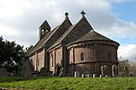 More images |
| Church of St John the Baptist | King's Caple | Parish Church | 13th century | 25 February 1966 | SO5589128836 51°57′23″N 2°38′36″W / 51.95625°N 2.643283°W / 51.95625; -2.643283 (Church of St John the Baptist) | 1349008 |  More images |
| Church of St Mary | King's Pyon | Parish Church | 12th century | 2 September 1966 | SO4386550625 52°09′04″N 2°49′19″W / 52.15104°N 2.821855°W / 52.15104; -2.821855 (Church of St Mary) | 1179970 | 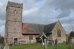 More images |
| Church of St Michael | Kingsland | Parish Church | 13th century | 11 June 1959 | SO4468361287 52°14′49″N 2°48′42″W / 52.246969°N 2.811646°W / 52.246969; -2.811646 (Church of St Michael) | 1167022 |  More images |
| Church of St Mary | Kington | Parish Church | c. 1300 | 8 October 1953 | SO2913556762 52°12′16″N 3°02′18″W / 52.204509°N 3.038391°W / 52.204509; -3.038391 (Church of St Mary) | 1208031 |  More images |
| Church of St James | Kinnersley | Parish church | C12, 13th century and 14th century | 2 September 1966 | SO3455649618 52°08′27″N 2°57′28″W / 52.140962°N 2.957697°W / 52.140962; -2.957697 (Church of St James) | 1157630 |  More images |
| Church of St Andrew | Laysters (or Leysters) | Parish Church | 12th century | 11 June 1959 | SO5683763250 52°15′57″N 2°38′02″W / 52.265706°N 2.633892°W / 52.265706; -2.633892 (Church of St Andrew) | 1166945 |  More images |
| Church of St Michael and All Angels, Including the detached Bell Tower | Ledbury | Bell Tower | c. 1230 | 18 September 1953 | SO7128137697 52°02′13″N 2°25′12″W / 52.036926°N 2.420081°W / 52.036926; -2.420081 (Church of St Michael and All Angels, Including the detached Bell Tower) | 1301825 |  More images |
| Ledbury Park | Ledbury Park, Ledbury | House | 1590 | 18 September 1953 | SO7113837564 52°02′09″N 2°25′20″W / 52.035723°N 2.422154°W / 52.035723; -2.422154 (Ledbury Park) | 1180078 |  More images |
| Market House | Ledbury | Market House | c. 1617 | 18 September 1953 | SO7110237708 52°02′13″N 2°25′22″W / 52.037015°N 2.422691°W / 52.037015; -2.422691 (Market House) | 1349392 |  More images |
| Church of St Mary Magdalene | Leintwardine | Anglican Church | 1865 | 11 June 1959 | SO4046274095 52°21′42″N 2°52′33″W / 52.361661°N 2.875732°W / 52.361661; -2.875732 (Church of St Mary Magdalene) | 1349757 | 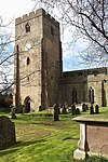 More images |
| The Priory Church of St Peter and St Paul | Leominster | Parish Church | 13th century | 24 July 1954 | SO4985259278 52°13′46″N 2°44′08″W / 52.229405°N 2.735644°W / 52.229405; -2.735644 (The Priory Church of St Peter and St Paul) | 1077617 |  More images |
| Church of St John the Baptist | Letton | Parish Church | C12, C13 and 14th century | 2 September 1966 | SO3351246451 52°06′45″N 2°58′20″W / 52.112368°N 2.97233°W / 52.112368; -2.97233 (Church of St John the Baptist) | 1157735 |  More images |
| Church of St Mary | Linton | Church | 12th century | 17 March 1987 | SO6602125332 51°55′32″N 2°29′44″W / 51.925461°N 2.49553°W / 51.925461; -2.49553 (Church of St Mary) | 1167319 |  More images |
| Church of St Deinst | Llangarron | Parish Church | 14th century | 26 February 1966 | SO5303721169 51°53′14″N 2°41′02″W / 51.887089°N 2.683762°W / 51.887089; -2.683762 (Church of St Deinst) | 1348911 |  More images |
| Church of St Clodock | Clodock, Longtown | Parish Church | 12th century | 26 January 1967 | SO3264827513 51°56′31″N 2°58′52″W / 51.942023°N 2.98121°W / 51.942023; -2.98121 (Church of St Clodock) | 1078150 | 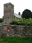 More images |
| Church of the Nativity of the Blessed Virgin Mary | Madley | Parish Church | 12th century | 26 January 1962 | SO4199838720 52°02′38″N 2°50′50″W / 52.043826°N 2.847109°W / 52.043826; -2.847109 (Church of the Nativity of the Blessed Virgin Mary) | 1348768 |  More images |
| Amberley Court | Amberley, Marden | Hall House | Early 14th century | 20 October 1952 | SO5458047808 52°07′36″N 2°39′54″W / 52.126703°N 2.664886°W / 52.126703; -2.664886 (Amberley Court) | 1302188 |  More images |
| Church of St Mary | Marden | Parish Church | 13th century and 14th century | 26 January 1967 | SO5118047057 52°07′11″N 2°42′52″W / 52.119662°N 2.714439°W / 52.119662; -2.714439 (Church of St Mary) | 1302203 |  More images |
| Church of St Mary | Middleton on the Hill | Parish Church | 12th century | 11 June 1959 | SO5405264606 52°16′40″N 2°40′30″W / 52.27767°N 2.674883°W / 52.27767; -2.674883 (Church of St Mary) | 1167020 |  More images |
| Church of St Michael and All Angels | Moccas Park, Moccas | Parish Church | Mid 12th century | 2 September 1966 | SO3574343275 52°05′03″N 2°56′21″W / 52.084082°N 2.939156°W / 52.084082; -2.939156 (Church of St Michael and All Angels) | 1157759 |  More images |
| Moccas Court | Moccas Park, Moccas | Country House | 1775-81 | 2 September 1966 | SO3577043533 52°05′11″N 2°56′20″W / 52.086404°N 2.93881°W / 52.086404; -2.93881 (Moccas Court) | 1081852 | 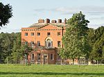 More images |
| Church of Saints Cosmas and Damian | Stretford, Monkland and Stretford | Parish Church | 12th century | 2 September 1966 | SO4435055741 52°11′49″N 2°48′56″W / 52.19708°N 2.815608°W / 52.19708; -2.815608 (Church of Saints Cosmas and Damian) | 1349846 |  More images |
| Church of St Mary | Much Cowarne | Church | Early 13th century | 9 June 1967 | SO6186347133 52°07′16″N 2°33′30″W / 52.121187°N 2.55843°W / 52.121187; -2.55843 (Church of St Mary) | 1082241 |  More images |
| Church of St David | Much Dewchurch | Parish Church | 12th century | 26 January 1967 | SO4822431117 51°58′34″N 2°45′19″W / 51.976094°N 2.755188°W / 51.976094; -2.755188 (Church of St David) | 1348822 |  More images |
| The Mynde | Much Dewchurch | House | 15th century and 16th century | 20 October 1952 | SO4706829726 51°57′49″N 2°46′18″W / 51.96348°N 2.771801°W / 51.96348; -2.771801 (The Mynde) | 1348825 |  More images |
| Church of St Bartholomew | Much Marcle | Parish Church | C13-C15 | 6 March 1967 | SO6570832746 51°59′32″N 2°30′03″W / 51.992097°N 2.500824°W / 51.992097; -2.500824 (Church of St Bartholomew) | 1156241 |  More images |
| Summerhouse about 100 yards West South West of Homme House | Much Marcle | Summerhouse | Late 17th century | 6 March 1967 | SO6526531788 51°59′00″N 2°30′26″W / 51.983457°N 2.507178°W / 51.983457; -2.507178 (Summerhouse about 100 yards West South West of Homme House) | 1099011 | Upload Photo |
| Church of St George | Orleton | Parish Church | 12th century | 11 June 1959 | SO4943467174 52°18′01″N 2°44′35″W / 52.300348°N 2.742949°W / 52.300348; -2.742949 (Church of St George) | 1349873 | 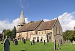 More images |
| Belfry about 5 metres North-east of the Church of St Mary | Pembridge | Bell Tower | Early 13th-century origins | 16 October 1967 | SO3911058086 52°13′03″N 2°53′34″W / 52.217605°N 2.892685°W / 52.217605; -2.892685 (Belfry about 5 metres North-east of the Church of St Mary) | 1301249 |  More images |
| Church of St Mary | Pembridge | Parish Church | 12th century and 13th century | 16 October 1967 | SO3909558052 52°13′02″N 2°53′34″W / 52.217298°N 2.892899°W / 52.217298; -2.892899 (Church of St Mary) | 1081754 |  More images |
| Church of St Peter | Peterchurch | Parish Church | Mid 12th century | 26 January 1967 | SO3449638520 52°02′28″N 2°57′23″W / 52.041191°N 2.956437°W / 52.041191; -2.956437 (Church of St Peter) | 1296560 |  More images |
| Wellbrook Manor | Peterchurch | Aisled House | 2nd half 14th century | 29 September 1952 | SO3508638469 52°02′27″N 2°56′52″W / 52.040802°N 2.947827°W / 52.040802; -2.947827 (Wellbrook Manor) | 1099488 |  More images |
| Church of St Giles | Aston, Pipe Aston | Parish Church | 12th century | 11 June 1959 | SO4612471793 52°20′30″N 2°47′32″W / 52.341555°N 2.792225°W / 52.341555; -2.792225 (Church of St Giles) | 1349901 | 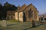 More images |
| Church of St Bartholomew | Richards Castle | Parish Church | 12th century | 11 June 1959 | SO4843370280 52°19′41″N 2°45′29″W / 52.328176°N 2.758104°W / 52.328176; -2.758104 (Church of St Bartholomew) | 1167572 |  More images |
| Dovecote about 10 metres West of Court House Farmhouse | Richards Castle | Dovecote | 17th century | 11 June 1959 | SO4912669840 52°19′27″N 2°44′52″W / 52.324286°N 2.747869°W / 52.324286; -2.747869 (Dovecote about 10 metres West of Court House Farmhouse) | 1167549 |  More images |
| Tower about 10 metres East of Church of St Bartholomew | Richards Castle | Tower | 14th century | 11 December 1987 | SO4846170277 52°19′41″N 2°45′28″W / 52.328152°N 2.757693°W / 52.328152; -2.757693 (Tower about 10 metres East of Church of St Bartholomew) | 1081780 |  |
| Rudhall Manor | Rudhall, Ross-on-Wye[note 4] | Hall House | 14th century | 25 February 1966 | SO6254425383 51°55′33″N 2°32′46″W / 51.925696°N 2.546096°W / 51.925696; -2.546096 (Rudhall Manor) | 1099663 |  |
| Church of St Mary the Virgin | Ross-on-Wye | Church | 17th century | 22 October 1952 | SO5979824046 51°54′49″N 2°35′09″W / 51.913484°N 2.58587°W / 51.913484; -2.58587 (Church of St Mary the Virgin) | 1098720 |  More images |
| Wilton Bridge (that Part in Ross on Wye Urban District) | Ross-on-Wye | Bridge | 1597-1599 | 22 October 1952 | SO5899724214 51°54′54″N 2°35′51″W / 51.914936°N 2.597534°W / 51.914936; -2.597534 (Wilton Bridge (that Part in Ross on Wye Urban District)) | 1349266 |  More images |
| Church of St Peter | Rowlstone | Parish Church | 12th century | 26 January 1967 | SO3737827131 51°56′21″N 2°54′44″W / 51.939143°N 2.912341°W / 51.939143; -2.912341 (Church of St Peter) | 1078157 | 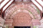 More images |
| Church of St Mary | Sarnesfield | Anglican Church | c. 1870 | 2 September 1966 | SO3747250925 52°09′11″N 2°54′55″W / 52.153049°N 2.915335°W / 52.153049; -2.915335 (Church of St Mary) | 1349517 |  More images |
| Church of St Tysilio | Sellack | Church | 1711 | 26 March 1987 | SO5653527659 51°56′45″N 2°38′02″W / 51.94572°N 2.633762°W / 51.94572; -2.633762 (Church of St Tysilio) | 1214929 |  More images |
| Church of St John the Evangelist | Shobdon Park, Shobdon | Parish Church | 14th century | 11 June 1959 | SO4011462847 52°15′38″N 2°52′44″W / 52.260513°N 2.878837°W / 52.260513; -2.878837 (Church of St John the Evangelist) | 1166734 |  More images |
| Church of St Margaret | St Margarets | Parish Church | 12th century | 26 January 1967 | SO3537933777 51°59′55″N 2°56′34″W / 51.998658°N 2.942668°W / 51.998658; -2.942668 (Church of St Margaret) | 1266723 |  More images |
| Church of St Weonard | St Weonards | Church | 13th century | 30 April 1986 | SO4961024333 51°54′55″N 2°44′02″W / 51.915233°N 2.734015°W / 51.915233; -2.734015 (Church of St Weonard) | 1179982 |  More images |
| Treago | St. Weonards, Herefordshire | Fortified House | Late 15th century or early 16th century | 30 April 1986 | SO4902123910 51°54′41″N 2°44′33″W / 51.911377°N 2.742515°W / 51.911377; -2.742515 (Treago) | 1099712 |  More images |
| Church of St Mary | Staunton on Wye | Parish Church | C12, C13 and 14th century | 2 September 1966 | SO3755144833 52°05′54″N 2°54′47″W / 52.098295°N 2.91306°W / 52.098295; -2.91306 (Church of St Mary) | 1166457 |  More images |
| Church of St Mary | Stoke Edith | Anglican Church | 17th century | 26 January 1967 | SO6040340656 52°03′46″N 2°34′44″W / 52.062855°N 2.578998°W / 52.062855; -2.578998 (Church of St Mary) | 1099825 |  More images |
| Church of St Lawrence | Stretton Grandison | Parish Church | Early 12th century | 6 March 1967 | SO6328544073 52°05′38″N 2°32′14″W / 52.093774°N 2.537331°W / 52.093774; -2.537331 (Church of St Lawrence) | 1157113 |  More images |
| Church of St Bartholomew | Thruxton | Parish Church | 14th century | 26 January 1962 | SO4371434624 52°00′26″N 2°49′17″W / 52.007182°N 2.821416°W / 52.007182; -2.821416 (Church of St Bartholomew) | 1178827 |  More images |
| Churchyard Cross about 8 yards South of the Chancel of the Church of St Mary | Tyberton | Cross | 14th century | 21 February 1986 | SO3803539881 52°03′14″N 2°54′18″W / 52.053834°N 2.905094°W / 52.053834; -2.905094 (Churchyard Cross about 8 yards South of the Chancel of the Church of St Mary) | 1179124 |  More images |
| Church of St John the Baptist | Upton Bishop | Parish Church | 12th century | 25 February 1966 | SO6502527210 51°56′32″N 2°30′37″W / 51.942283°N 2.510205°W / 51.942283; -2.510205 (Church of St John the Baptist) | 1166738 |  More images |
| Church of St Bartholomew | Vowchurch | Parish Church | 12th century | 26 January 1967 | SO3619036467 52°01′23″N 2°55′53″W / 52.022934°N 2.931359°W / 52.022934; -2.931359 (Church of St Bartholomew) | 1225063 |  More images |
| Church of St Michael | Walford | Church | 12th century | 17 March 1987 | SO5862220424 51°52′51″N 2°36′09″W / 51.880834°N 2.60253°W / 51.880834; -2.60253 (Church of St Michael) | 1167585 |  More images |
| Hill Court Manor | Walford | Country House | 1698-1700 | 18 May 1953 | SO5750621652 51°53′30″N 2°37′08″W / 51.89179°N 2.618893°W / 51.89179; -2.618893 (Hill Court Manor) | 1099665 |  More images |
| Church of St Margaret | Wellington | Parish Church | Late 12th century | 15 July 1985 | SO4971948201 52°07′47″N 2°44′09″W / 52.129815°N 2.735945°W / 52.129815; -2.735945 (Church of St Margaret) | 1099322 | 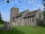 More images |
| Church of St Mary | Welsh Newton | Parish Church | 13th century | 25 February 1966 | SO4996118022 51°51′31″N 2°43′41″W / 51.858528°N 2.727995°W / 51.858528; -2.727995 (Church of St Mary) | 1224918 |  More images |
| Pembridge Castle | Welsh Newton | Castle | Late 12th century or early 13th century | 25 February 1966 | SO4881319274 51°52′11″N 2°44′41″W / 51.86968°N 2.744849°W / 51.86968; -2.744849 (Pembridge Castle) | 1224913 |  More images |
| The Church of Saint Peter and Saint Paul | Weobley | Bell Tower | Mid 14th century | 2 September 1966 | SO4017751865 52°09′42″N 2°52′33″W / 52.161799°N 2.875969°W / 52.161799; -2.875969 (The Church of Saint Peter and Saint Paul) | 1301343 |  More images |
| The Ley | Weobley | House | Late 19th century | 20 February 1953 | SO3926351194 52°09′20″N 2°53′21″W / 52.155667°N 2.889209°W / 52.155667; -2.889209 (The Ley) | 1349847 |  More images |
| Church of St Bartholomew | Westhide | Parish Church | Late 12th century | 26 January 1967 | SO5862244191 52°05′40″N 2°36′19″W / 52.094505°N 2.605405°W / 52.094505; -2.605405 (Church of St Bartholomew) | 1301742 |  More images |
| Barn on West Side of Farmyard and Curtain Wall Enclosing Yard at Bollitree Castle | Weston under Penyard | Curtain Wall | Mid 18th century | 18 May 1953 | SO6367724032 51°54′49″N 2°31′46″W / 51.913625°N 2.529478°W / 51.913625; -2.529478 (Barn on West Side of Farmyard and Curtain Wall Enclosing Yard at Bollitree Castle) | 1296781 |  |
| Chapel Farmhouse | Deerfold, Wigmore | Farmhouse | Early 15th century | 11 June 1959 | SO3942868435 52°18′38″N 2°53′24″W / 52.310669°N 2.889892°W / 52.310669; -2.889892 (Chapel Farmhouse) | 1081779 | Upload Photo |
| Church of St James | Wigmore | Parish Church | Late 11th century | 11 June 1959 | SO4129269066 52°19′00″N 2°51′46″W / 52.316544°N 2.862665°W / 52.316544; -2.862665 (Church of St James) | 1178822 | 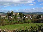 More images |
| Ruins of Wigmore Castle | Wigmore | Castle | MID 11th century ORIGINS | 11 June 1959 | SO4083969220 52°19′04″N 2°52′10″W / 52.31788°N 2.869337°W / 52.31788; -2.869337 (Ruins of Wigmore Castle) | 1178673 | 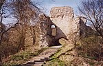 More images |
See also
- Category:Grade I listed buildings in Herefordshire
- Grade II* listed buildings in Herefordshire
Notes
- ^ The date given is the date used by Historic England as significant for the initial building or that of an important part in the structure's description.
- ^ Sometimes known as OSGB36, the grid reference is based on the British national grid reference system used by the Ordnance Survey.
- ^ The "List Entry Number" is a unique number assigned to each listed building and scheduled monument by Historic England.
- ^ Rudhall House has two Historic England listings as the house sits at the junction of three civil parishes. This listing relates to that part of the house sited in Ross Rural Civil Parish, and 1099260 to that part of the house which sits in Brampton Abbotts Civil Parish
References
National Heritage List for England
External links
![]() Media related to Grade I listed buildings in Herefordshire at Wikimedia Commons
Media related to Grade I listed buildings in Herefordshire at Wikimedia Commons
- v
- t
- e
- Bedfordshire
- Berkshire
- Bristol
- Buckinghamshire
- Cambridgeshire
- Cheshire
- Cornwall
- Cumbria
- Derbyshire
- Devon
- Dorset
- Durham
- East Sussex
- East Riding of Yorkshire
- Essex
- Gloucestershire
- Greater London
- Greater Manchester
- Hampshire
- Herefordshire
- Hertfordshire
- Isle of Wight
- Kent
- Lancashire
- Leicestershire
- Lincolnshire
- Merseyside
- Norfolk
- North Yorkshire
- Northamptonshire
- Northumberland
- Nottinghamshire
- Oxfordshire
- Rutland
- Shropshire
- Somerset
- South Yorkshire
- Staffordshire
- Suffolk
- Surrey
- Tyne and Wear
- Warwickshire
- West Midlands
- West Sussex
- West Yorkshire
- Wiltshire
- Worcestershire
- Babergh
- Bath and North East Somerset
- Bradford
- Brighton and Hove
- Broadland
- Cheltenham
- Cheshire East
- Cheshire West and Chester
- Cotswold
- Craven
- Dartford
- Dover
- Forest Heath
- Forest of Dean
- Ipswich
- Maidstone
- Mendip
- Mid Suffolk
- North Somerset
- Sedgemoor
- South Gloucestershire
- South Somerset
- St Edmundsbury
- Stroud
- Suffolk Coastal
- Taunton Deane
- Tewkesbury
- Waveney
- West Somerset
- Churches
- War memorials
- 20th century


