Grade I listed buildings in South Gloucestershire

Map all coordinates using OpenStreetMap
Download coordinates as:
- KML
- GPX (all coordinates)
- GPX (primary coordinates)
- GPX (secondary coordinates)
There are over 9,000 Grade I listed buildings in England. This page is a list of these buildings in the district of South Gloucestershire within Gloucestershire.
South Gloucestershire
| Name | Location | Type | Completed [note 1] | Date designated | Grid ref.[note 2] Geo-coordinates | Entry number [note 3] | Image |
|---|---|---|---|---|---|---|---|
| Church of St Mary | Almondsbury, South Gloucestershire | Parish Church | Late 12th century | 30 March 1960 | ST6034884085 51°33′15″N 2°34′24″W / 51.554248°N 2.573308°W / 51.554248; -2.573308 (Church of St Mary) | 1128858 |  More images |
| Severn Bridge and Aust Viaduct First Severn Crossing | Aust | Suspension Bridge | 1961-1966 | 29 May 1998 | ST5654089830 51°36′20″N 2°37′44″W / 51.605619°N 2.628942°W / 51.605619; -2.628942 (Severn Bridge and Aust Viaduct First Severn Crossing) | 1119760 |  More images |
| Badminton House | Badminton Park, Badminton | Country House | Late 1660s to 1690s | 17 September 1952 | ST8066682913 51°32′41″N 2°16′49″W / 51.544777°N 2.280196°W / 51.544777; -2.280196 (Badminton House) | 1320832 |  More images |
| Church of St Michael and All Angels | Badminton Park, Badminton | Anglican Church | 1785 | 3 March 1961 | ST8068682866 51°32′40″N 2°16′48″W / 51.544355°N 2.279905°W / 51.544355; -2.279905 (Church of St Michael and All Angels) | 1155177 |  More images |
| Parish Church of St Mary | Bitton | Parish Church | Anglo Saxon origins | 11 May 1953 | ST6819469334 51°25′20″N 2°27′32″W / 51.422118°N 2.458813°W / 51.422118; -2.458813 (Parish Church of St Mary) | 1116770 |  More images |
| Church of St James | Charfield | Church | Redundant | 30 March 1960 | ST7190091098 51°37′05″N 2°24′26″W / 51.617999°N 2.407259°W / 51.617999; -2.407259 (Church of St James) | 1321189 |  More images |
| Church of Holy Trinity | Cold Ashton | Parish Church | 14th century | 15 August 1985 | ST7510372737 51°27′11″N 2°21′35″W / 51.453062°N 2.359693°W / 51.453062; -2.359693 (Church of Holy Trinity) | 1220484 | 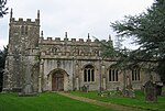 More images |
| Garden Walls and Gateways about 15m South of the Manor House | Cold Ashton | Gate | Early 17th century | 17 September 1952 | ST7501372614 51°27′07″N 2°21′40″W / 51.451952°N 2.360979°W / 51.451952; -2.360979 (Garden Walls and Gateways about 15m South of the Manor House) | 1290769 | 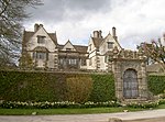 |
| The Manor House | Cold Ashton | House | c 1570-75 | 17 September 1952 | ST7500472638 51°27′08″N 2°21′40″W / 51.452168°N 2.361111°W / 51.452168; -2.361111 (The Manor House) | 1220865 | More images |
| Parish Church of St Andrew | Cromhall | Anglican Church | 1852 | 30 March 1960 | ST6922290501 51°36′45″N 2°26′45″W / 51.61249°N 2.445885°W / 51.61249; -2.445885 (Parish Church of St Andrew) | 1114974 |  More images |
| Church of St Mary | Dodington Park, Dodington | Church (private) | Medieval | 15 August 1985 | ST7520979880 51°31′02″N 2°21′31″W / 51.517292°N 2.358671°W / 51.517292; -2.358671 (Church of St Mary) | 1211173 |  Upload Photo |
| Dodington House | Dodington Park, Dodington | House | 1796-1816 | 17 September 1952 | ST7525079860 51°31′02″N 2°21′29″W / 51.517114°N 2.358079°W / 51.517114; -2.358079 (Dodington House) | 1211169 |  More images |
| Dower House | Dodington Park, Dodington | Dower House | Between 1796 and 1816 | 17 September 1952 | ST7521979938 51°31′04″N 2°21′31″W / 51.517814°N 2.358531°W / 51.517814; -2.358531 (Dower House) | 1290138 | Upload Photo |
| Orangery attached to North West of Dodington House | Dodington Park, Dodington | Orangery | 1799 | 15 August 1985 | ST7522079873 51°31′02″N 2°21′31″W / 51.517229°N 2.358512°W / 51.517229; -2.358512 (Orangery attached to North West of Dodington House) | 1211172 | Upload Photo |
| Stables | Dodington Park, Dodington | Courtyard | 1796-1816 | 17 September 1952 | ST7517979918 51°31′03″N 2°21′33″W / 51.517632°N 2.359106°W / 51.517632; -2.359106 (Stables) | 1290139 | Upload Photo |
| Church of St Peter | Dyrham Park, Dyrham and Hinton | Parish Church | Mid 13th century | 15 August 1985 | ST7414475804 51°28′50″N 2°22′25″W / 51.480595°N 2.373719°W / 51.480595; -2.373719 (Church of St Peter) | 1289711 |  More images |
| Dyrham House | Dyrham Park, Dyrham and Hinton | Country House | Tudor | 17 September 1952 | ST7418075766 51°28′49″N 2°22′24″W / 51.480255°N 2.373198°W / 51.480255; -2.373198 (Dyrham House) | 1212039 |  More images |
| Orangery attached to South East of Dyrham House | Dyrham Park, Dyrham and Hinton | Glasshouse | 1701 | 15 August 1985 | ST7418375734 51°28′48″N 2°22′23″W / 51.479968°N 2.373153°W / 51.479968; -2.373153 (Orangery attached to South East of Dyrham House) | 1212042 |  More images |
| Stable Block attached to South of Dyrham House | Dyrham Park, Dyrham and Hinton | Stables | 1698 | 15 August 1985 | ST7415275729 51°28′48″N 2°22′25″W / 51.479921°N 2.373599°W / 51.479921; -2.373599 (Stable Block attached to South of Dyrham House) | 1289719 | 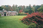 More images |
| Church of St Michael and All Angels | Little Badminton, Hawkesbury | Church | Early 13th century | 3 March 1961 | ST8017084252 51°33′24″N 2°17′15″W / 51.556799°N 2.287424°W / 51.556799; -2.287424 (Church of St Michael and All Angels) | 1303100 |  More images |
| Parish Church of St Mary the Virgin | Hawkesbury | Church | 13th century | 3 March 1961 | ST7681986925 51°34′51″N 2°20′09″W / 51.580704°N 2.335936°W / 51.580704; -2.335936 (Parish Church of St Mary the Virgin) | 1320866 |  More images |
| Swangrove House, Garden Walls, 4 Corner Pavilions and Gate Piers | Swangrove, Hawkesbury | House | 1703 | 17 September 1952 | ST7970585752 51°34′13″N 2°17′39″W / 51.570269°N 2.294218°W / 51.570269; -2.294218 (Swangrove House, Garden Walls, 4 Corner Pavilions and Gate Piers) | 1129379 | Upload Photo |
| Ambulatory 20m south-west of Horton Court | Horton | Loggia | c1527-1529 | 17 September 1952 | ST7661584989 51°33′48″N 2°20′20″W / 51.563288°N 2.33875°W / 51.563288; -2.33875 (Ambulatory 20m south-west of Horton Court) | 1321166 |  |
| Horton Court | Horton | Clergy House | c. 1140 | 17 September 1952 | ST7662285029 51°33′49″N 2°20′19″W / 51.563648°N 2.338652°W / 51.563648; -2.338652 (Horton Court) | 1114992 | 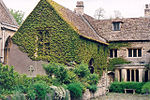 More images |
| Parish Church of St James the Elder | Horton | Anglican Church | 16th century | 3 March 1961 | ST7660085035 51°33′49″N 2°20′20″W / 51.563701°N 2.33897°W / 51.563701; -2.33897 (Parish Church of St James the Elder) | 1114993 | 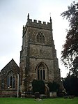 More images |
| Acton Court and Gateway and Flank Walls 40m East | Iron Acton | Farmhouse | 1680 | 9 February 2011 | ST6771084203 51°33′21″N 2°28′02″W / 51.55578°N 2.467139°W / 51.55578; -2.467139 (Acton Court and Gateway and Flank Walls 40m East) | 1320155 |  More images |
| Church of St James the Less | Iron Acton | Anglican Church | 1879 | 27 November 1984 | ST6806583452 51°32′57″N 2°27′43″W / 51.549048°N 2.46195°W / 51.549048; -2.46195 (Church of St James the Less) | 1320130 |  More images |
| Little Sodbury Manor | Little Sodbury | Manor House | Early 15th century | 17 September 1952 | ST7598082897 51°32′40″N 2°20′52″W / 51.544452°N 2.347767°W / 51.544452; -2.347767 (Little Sodbury Manor) | 1115005 | Upload Photo |
| Parish Church of St Mary | Marshfield | Parish church | 12th century | 3 March 1961 | ST7821473677 51°27′42″N 2°18′54″W / 51.461643°N 2.31498°W / 51.461643; -2.31498 (Parish Church of St Mary) | 1129438 |  More images |
| Anglican Church of St Thomas à Becket / Church of St Thomas of Canterbury | Pucklechurch | Parish Church | Norman origin | 15 August 1985 | ST6992576533 51°29′13″N 2°26′04″W / 51.486941°N 2.434534°W / 51.486941; -2.434534 (Anglican Church of St Thomas à Becket / Church of St Thomas of Canterbury) | 1212871 |  More images |
| Parish Church of St Anne | Siston | Church | Mid 12th century | 11 May 1953 | ST6885475232 51°28′31″N 2°26′59″W / 51.475185°N 2.449843°W / 51.475185; -2.449843 (Parish Church of St Anne) | 1278090 |  More images |
| Siston Court | Siston | House | Mid C20 | 11 May 1953 | ST6866175361 51°28′35″N 2°27′09″W / 51.476334°N 2.452633°W / 51.476334; -2.452633 (Siston Court) | 1231511 |  More images |
| Parish Church of St John the Baptist | Chipping Sodbury | Parish Church | Early English | 29 July 1983 | ST7274882301 51°32′20″N 2°23′40″W / 51.538946°N 2.394326°W / 51.538946; -2.394326 (Parish Church of St John the Baptist) | 1129307 |  More images |
| Church of St Mary the Virgin | Thornbury | Church | 1764 | 30 March 1960 | ST6340090620 51°36′48″N 2°31′48″W / 51.613211°N 2.529974°W / 51.613211; -2.529974 (Church of St Mary the Virgin) | 1128789 |  More images |
| Outer Court of Thornbury Castle and Wall of Kitchen Court | Thornbury | Castle | 1511-1521 | 21 September 1952 | ST6331490720 51°36′51″N 2°31′52″W / 51.614104°N 2.531226°W / 51.614104; -2.531226 (Outer Court of Thornbury Castle and Wall of Kitchen Court) | 1321132 |  |
| Thornbury Castle, Inner Court | Thornbury | Castle | 1510-1521 | 21 September 1952 | ST6336590701 51°36′50″N 2°31′50″W / 51.613937°N 2.530488°W / 51.613937; -2.530488 (Thornbury Castle, Inner Court) | 1128788 | 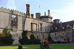 |
| Walls enclosing Privy Garden immediately to South of the Inner Court of Thornbury Castle | Thornbury | Wall | 1511-21 | 21 September 1952 | ST6343390678 51°36′49″N 2°31′46″W / 51.613734°N 2.529503°W / 51.613734; -2.529503 (Walls enclosing Privy Garden immediately to South of the Inner Court of Thornbury Castle) | 1312668 | 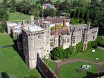 |
| Bath Lodge | Dodington Ash, Tormarton | Lodge | 1796-1816 | 17 September 1952 | ST7582378492 51°30′17″N 2°20′59″W / 51.504839°N 2.349727°W / 51.504839; -2.349727 (Bath Lodge) | 1214012 |  More images |
| Church of St Mary Magdelene | Tormarton | Parish Church | Norman | 15 August 1985 | ST7695178847 51°30′29″N 2°20′01″W / 51.508078°N 2.333499°W / 51.508078; -2.333499 (Church of St Mary Magdelene) | 1213492 | 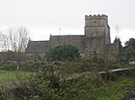 More images |
| Church of St James the Great | Westerleigh | Parish Church | 13th century | 15 August 1985 | ST6995279653 51°30′54″N 2°26′04″W / 51.514995°N 2.434412°W / 51.514995; -2.434412 (Church of St James the Great) | 1215174 |  More images |
| Church of St James the Great | Abson, Wick and Abson | Parish Church | 12th century | 15 August 1985 | ST7053174845 51°28′18″N 2°25′32″W / 51.471795°N 2.425665°W / 51.471795; -2.425665 (Church of St James the Great) | 1216114 |  More images |
| Wick Court | Wick and Abson | House | Later | 17 September 1952 | ST7005672665 51°27′08″N 2°25′56″W / 51.452169°N 2.432318°W / 51.452169; -2.432318 (Wick Court) | 1216153 |  More images |
| Church of St Michael | Winterbourne | Anglican Church | Mid-late 19th century | 3 March 1961 | ST6413781006 51°31′37″N 2°31′06″W / 51.526819°N 2.518346°W / 51.526819; -2.518346 (Church of St Michael) | 1321086 |  More images |
| Parish Church of St Mary the Virgin | Yate | Anglican Church | 1859 | 3 March 1961 | ST7137082815 51°32′37″N 2°24′51″W / 51.543499°N 2.414236°W / 51.543499; -2.414236 (Parish Church of St Mary the Virgin) | 1128753 | 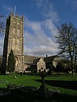 More images |
| Whitfield's Tabernacle | Park Road, Bristol | Chapel | 1741 | 6 June 1951 | ST6493173903 51°27′47″N 2°30′22″W / 51.463005°N 2.506193°W / 51.463005; -2.506193 (Whitfield's Tabernacle) | 1116201 |  More images |
Notes
- ^ The date given is the date used by Historic England as significant for the initial building or that of an important part in the structure's description.
- ^ Sometimes known as OSGB36, the grid reference is based on the British national grid reference system used by the Ordnance Survey.
- ^ The "List Entry Number" is a unique number assigned to each listed building and scheduled monument by Historic England.
References
National Heritage List for England
External links
- v
- t
- e
- Bedfordshire
- Berkshire
- Bristol
- Buckinghamshire
- Cambridgeshire
- Cheshire
- Cornwall
- Cumbria
- Derbyshire
- Devon
- Dorset
- Durham
- East Sussex
- East Riding of Yorkshire
- Essex
- Gloucestershire
- Greater London
- Greater Manchester
- Hampshire
- Herefordshire
- Hertfordshire
- Isle of Wight
- Kent
- Lancashire
- Leicestershire
- Lincolnshire
- Merseyside
- Norfolk
- North Yorkshire
- Northamptonshire
- Northumberland
- Nottinghamshire
- Oxfordshire
- Rutland
- Shropshire
- Somerset
- South Yorkshire
- Staffordshire
- Suffolk
- Surrey
- Tyne and Wear
- Warwickshire
- West Midlands
- West Sussex
- West Yorkshire
- Wiltshire
- Worcestershire
- Babergh
- Bath and North East Somerset
- Bradford
- Brighton and Hove
- Broadland
- Cheltenham
- Cheshire East
- Cheshire West and Chester
- Cotswold
- Craven
- Dartford
- Dover
- Forest Heath
- Forest of Dean
- Ipswich
- Maidstone
- Mendip
- Mid Suffolk
- North Somerset
- Sedgemoor
- South Gloucestershire
- South Somerset
- St Edmundsbury
- Stroud
- Suffolk Coastal
- Taunton Deane
- Tewkesbury
- Waveney
- West Somerset
- Churches
- War memorials
- 20th century


