Grade I listed buildings in North Lincolnshire
Map all coordinates using OpenStreetMap
Download coordinates as:
- KML
- GPX (all coordinates)
- GPX (primary coordinates)
- GPX (secondary coordinates)
There are over 9,000 Grade I listed buildings in England. This page is a list of these buildings in the district of North Lincolnshire in Lincolnshire.
North Lincolnshire
| Name | Location | Type | Completed [note 1] | Date designated | Grid ref.[note 2] Geo-coordinates | Entry number [note 3] | Image |
|---|---|---|---|---|---|---|---|
| Church of Saint John the Baptist | Alkborough | Church | Mid 11th century | 6 November 1967 | SE8820121891 53°41′10″N 0°39′57″W / 53.686038°N 0.665947°W / 53.686038; -0.665947 (Church of Saint John the Baptist) | 1241758 |  More images |
| Church of St Mary | Barnetby le Wold | Parish Church | C11-C12 | 6 November 1967 | TA0615209074 53°34′03″N 0°23′55″W / 53.567546°N 0.398608°W / 53.567546; -0.398608 (Church of St Mary) | 1103677 |  More images |
| Barrow Hall | Barrow upon Humber | House | 18th century | 6 November 1967 | TA0663420551 53°40′14″N 0°23′15″W / 53.670566°N 0.387408°W / 53.670566; -0.387408 (Barrow Hall) | 1288451 |  Upload Photo |
| Church of Holy Trinity | Barrow upon Humber | Parish Church | 13th century | 6 November 1967 | TA0721421433 53°40′42″N 0°22′42″W / 53.678372°N 0.378328°W / 53.678372; -0.378328 (Church of Holy Trinity) | 1346864 | 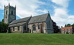 More images |
| Church of St Mary | Barton-upon-Humber | Church | Norman | 21 September 1966 | TA0334522021 53°41′04″N 0°26′12″W / 53.684433°N 0.436682°W / 53.684433; -0.436682 (Church of St Mary) | 1346773 |  More images |
| Church of St Peter | Barton-upon-Humber | Church | C9 | 21 September 1966 | TA0347821949 53°41′02″N 0°26′05″W / 53.68376°N 0.434693°W / 53.68376; -0.434693 (Church of St Peter) | 1083103 |  More images |
| Church of All Saints | Church Town, Belton | Parish Church | C14-C15 | 1 March 1967 | SE7829006336 53°32′52″N 0°49′12″W / 53.547832°N 0.819885°W / 53.547832; -0.819885 (Church of All Saints) | 1083293 |  More images |
| Church of St Peter Ad Vincula | Bottesford | Church | 13th century | 6 November 1967 | SE8994507021 53°33′08″N 0°38′38″W / 53.552123°N 0.643837°W / 53.552123; -0.643837 (Church of St Peter Ad Vincula) | 1083014 | 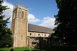 More images |
| Grammar School (original Portion) | Brigg | Grammar School | 1674 | 10 October 1952 | TA0015707452 53°33′15″N 0°29′23″W / 53.55415°N 0.489614°W / 53.55415; -0.489614 (Grammar School (original Portion)) | 1083127 |  More images |
| Church of St Mary | Broughton | Church | 1781 | 6 November 1967 | SE9603608625 53°33′56″N 0°33′05″W / 53.565459°N 0.551438°W / 53.565459; -0.551438 (Church of St Mary) | 1161801 | 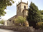 More images |
| Church of St Andrew | Burton upon Stather | Statue | 1776 | 6 November 1967 | SE8701617875 53°39′01″N 0°41′06″W / 53.650149°N 0.685009°W / 53.650149; -0.685009 (Church of St Andrew) | 1103747 |  More images |
| Normanby Hall | Normanby Park, Burton upon Stather | Country House | 1825-1830 | 19 October 1951 | SE8873016534 53°38′16″N 0°39′34″W / 53.637812°N 0.659468°W / 53.637812; -0.659468 (Normanby Hall) | 1103752 |  More images |
| Church of All Saints | Cadney | Parish Church | Mid 12th century | 6 November 1967 | TA0169503354 53°31′01″N 0°28′04″W / 53.517033°N 0.467737°W / 53.517033; -0.467737 (Church of All Saints) | 1083706 |  More images |
| Newstead Priory Farmhouse and Screen Wall Adjoining to Left | Cadney | Farmhouse | Early 19th century | 19 October 1951 | TA0000804457 53°31′38″N 0°29′34″W / 53.527267°N 0.492819°W / 53.527267; -0.492819 (Newstead Priory Farmhouse and Screen Wall Adjoining to Left) | 1346518 | Upload Photo |
| Church of St Oswald | Crowle | Cross | Anglo-Scandinavian | 1 March 1967 | SE7715312985 53°36′28″N 0°50′07″W / 53.607751°N 0.835401°W / 53.607751; -0.835401 (Church of St Oswald) | 1346672 |  More images |
| Church of Saint Peter | East Halton | Parish Church | 13th century | 6 November 1967 | TA1414618452 53°39′00″N 0°16′28″W / 53.650124°N 0.274527°W / 53.650124; -0.274527 (Church of Saint Peter) | 1103729 |  More images |
| Chest Tomb to Samuel Wesley Approximately 3 Metres South of Chancel of Church of St Andrew | Epworth | Grave Slab | 1735 | 10 September 1987 | SE7838604001 53°31′37″N 0°49′08″W / 53.526835°N 0.819021°W / 53.526835; -0.819021 (Chest Tomb to Samuel Wesley Approximately 3 Metres South of Chancel of Church of St Andrew) | 1083273 | Upload Photo |
| Church of St Andrew | Epworth | Manor House | Late C12-early 13th century | 1 March 1967 | SE7837804010 53°31′37″N 0°49′09″W / 53.526917°N 0.819139°W / 53.526917; -0.819139 (Church of St Andrew) | 1068692 |  More images |
| The Old Rectory | Epworth | House | 1956-7 | 27 September 1951 | SE7851503578 53°31′23″N 0°49′02″W / 53.523014°N 0.817181°W / 53.523014; -0.817181 (The Old Rectory) | 1068805 |  More images |
| Church of St Lawrence | Frodingham | Church | 12th century | 7 November 1966 | SE8910910841 53°35′12″N 0°39′19″W / 53.586592°N 0.655363°W / 53.586592; -0.655363 (Church of St Lawrence) | 1083610 | 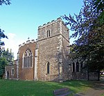 More images |
| Church of All Saints | Goxhill | Parish Church | 13th century | 6 November 1967 | TA1022421236 53°40′34″N 0°19′58″W / 53.675976°N 0.332849°W / 53.675976; -0.332849 (Church of All Saints) | 1288450 |  More images |
| Medieval Hall Adjoining North East Corner of Goxhill Hall | Goxhill | House | Late C14-early 15th century | 19 October 1951 | TA1095220517 53°40′10″N 0°19′20″W / 53.669363°N 0.32209°W / 53.669363; -0.32209 (Medieval Hall Adjoining North East Corner of Goxhill Hall) | 1288428 |  More images |
| Church of St Nicholas | Haxey | Gate | 1827 | 1 March 1967 | SK7647199834 53°29′23″N 0°50′56″W / 53.489669°N 0.848917°W / 53.489669; -0.848917 (Church of St Nicholas) | 1241103 |  More images |
| Church of Saint Maurice | Horkstow | Parish Church | 13th century | 6 November 1967 | SE9872118225 53°39′04″N 0°30′28″W / 53.651219°N 0.507875°W / 53.651219; -0.507875 (Church of Saint Maurice) | 1103736 |  More images |
| Church of St Oswald | Althorpe, Keadby with Althorpe | Parish Church | 1483 | 1 March 1967 | SE8347809625 53°34′36″N 0°44′27″W / 53.57659°N 0.740728°W / 53.57659; -0.740728 (Church of St Oswald) | 1083258 |  More images |
| Church of St Andrew | Kirton in Lindsey | Church | C11-C12 | 6 November 1967 | SK9341598559 53°28′32″N 0°35′38″W / 53.475481°N 0.593997°W / 53.475481; -0.593997 (Church of St Andrew) | 1083025 |  More images |
| Church of Saint Denys | North Killingholme | Parish Church | 12th century | 6 November 1967 | TA1448117357 53°38′25″N 0°16′12″W / 53.640213°N 0.269864°W / 53.640213; -0.269864 (Church of Saint Denys) | 1103701 |  More images |
| Church of St Martin | Owston Ferry | Bailey | Late 13th century | 1 March 1967 | SE8047800293 53°29′36″N 0°47′18″W / 53.493198°N 0.788421°W / 53.493198; -0.788421 (Church of St Martin) | 1083261 |  More images |
| Church of St Andrew | Redbourne | Parish Church | C14-C15 | 6 January 1987 | SK9734099944 53°29′14″N 0°32′04″W / 53.487216°N 0.534451°W / 53.487216; -0.534451 (Church of St Andrew) | 1346524 |  More images |
| Church of St Mary | Roxby cum Risby | Church | C11-C12 | 6 November 1967 | SE9206517019 53°38′30″N 0°36′32″W / 53.641595°N 0.6089°W / 53.641595; -0.6089 (Church of St Mary) | 1260342 |  More images |
| Scawby Hall | Scawby | Country House | c. 1603 | 6 November 1967 | SE9688005718 53°32′21″N 0°32′23″W / 53.539183°N 0.539599°W / 53.539183; -0.539599 (Scawby Hall) | 1083683 |  More images |
| Abbot's Lodge | Thornton Curtis | Abbey/Farmhouse | 17th century | 6 November 1967 | TA1178718854 53°39′15″N 0°18′36″W / 53.654244°N 0.310056°W / 53.654244; -0.310056 (Abbot's Lodge) | 1103713 |  More images |
| Church of Saint Lawrence | Thornton Curtis | Parish Church | Late C12-early 13th century | 6 November 1967 | TA0879617874 53°38′46″N 0°21′20″W / 53.64607°N 0.355633°W / 53.64607; -0.355633 (Church of Saint Lawrence) | 1227786 |  More images |
| Remains of Thornton Abbey Church and Adjoining Monastic Ranges | Thornton Curtis | Abbey | 1148 | 6 November 1967 | TA1180418932 53°39′18″N 0°18′35″W / 53.654942°N 0.30977°W / 53.654942; -0.30977 (Remains of Thornton Abbey Church and Adjoining Monastic Ranges) | 1215139 |  More images |
| Thornton Abbey Gatehouse and Wing Walls, Precinct Walls and Barbican | Thornton Curtis | Abbey | C15-C16 | 6 November 1967 | TA1151018967 53°39′19″N 0°18′51″W / 53.655319°N 0.314204°W / 53.655319; -0.314204 (Thornton Abbey Gatehouse and Wing Walls, Precinct Walls and Barbican) | 1346859 | 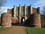 More images |
| Church of Saint Nicholas | Ulceby | Parish Church | C13-C14 | 6 November 1967 | TA1034014606 53°36′59″N 0°20′00″W / 53.616386°N 0.333444°W / 53.616386; -0.333444 (Church of Saint Nicholas) | 1227927 | 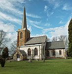 More images |
| Church of All Saints | Winteringham | Church | C11-12 | 6 November 1967 | SE9248522458 53°41′25″N 0°36′03″W / 53.690393°N 0.600931°W / 53.690393; -0.600931 (Church of All Saints) | 1117040 |  More images |
| Church of All Saints | Winterton | Church | Mid 11th century | 6 November 1967 | SE9283118590 53°39′20″N 0°35′49″W / 53.655576°N 0.596848°W / 53.655576; -0.596848 (Church of All Saints) | 1117004 |  More images |
| Church of St Andrew | Wootton | Parish Church | 13th century | 6 November 1967 | TA0890416172 53°37′51″N 0°21′17″W / 53.630755°N 0.354596°W / 53.630755; -0.354596 (Church of St Andrew) | 1204699 | 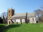 More images |
| Church of Saint Mary | Wrawby | Parish Church | Late C12-early 13th century | 6 November 1967 | TA0202808612 53°33′51″N 0°27′40″W / 53.564212°N 0.461005°W / 53.564212; -0.461005 (Church of Saint Mary) | 1281035 | 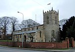 More images |
| Humber Bridge | Barton-upon-Humber | Suspension bridge | 1981 | 12 July 2017 | TA0241224487 53°42′24″N 0°27′00″W / 53.706773°N 0.44998943°W / 53.706773; -0.44998943 (Humber Bridge) | 1447321 |  More images |
Notes
- ^ The date given is the date used by Historic England as significant for the initial building or that of an important part in the structure's description.
- ^ Sometimes known as OSGB36, the grid reference is based on the British national grid reference system used by the Ordnance Survey.
- ^ The "List Entry Number" is a unique number assigned to each listed building and scheduled monument by Historic England.
External links
- v
- t
- e
- Bedfordshire
- Berkshire
- Bristol
- Buckinghamshire
- Cambridgeshire
- Cheshire
- Cornwall
- Cumbria
- Derbyshire
- Devon
- Dorset
- Durham
- East Sussex
- East Riding of Yorkshire
- Essex
- Gloucestershire
- Greater London
- Greater Manchester
- Hampshire
- Herefordshire
- Hertfordshire
- Isle of Wight
- Kent
- Lancashire
- Leicestershire
- Lincolnshire
- Merseyside
- Norfolk
- North Yorkshire
- Northamptonshire
- Northumberland
- Nottinghamshire
- Oxfordshire
- Rutland
- Shropshire
- Somerset
- South Yorkshire
- Staffordshire
- Suffolk
- Surrey
- Tyne and Wear
- Warwickshire
- West Midlands
- West Sussex
- West Yorkshire
- Wiltshire
- Worcestershire
- Babergh
- Bath and North East Somerset
- Bradford
- Brighton and Hove
- Broadland
- Cheltenham
- Cheshire East
- Cheshire West and Chester
- Cotswold
- Craven
- Dartford
- Dover
- Forest Heath
- Forest of Dean
- Ipswich
- Maidstone
- Mendip
- Mid Suffolk
- North Somerset
- Sedgemoor
- South Gloucestershire
- South Somerset
- St Edmundsbury
- Stroud
- Suffolk Coastal
- Taunton Deane
- Tewkesbury
- Waveney
- West Somerset
- Churches
- War memorials
- 20th century


